You are here: Home > Network List > II - Global Seismograph Network (GSN - IRIS/IDA) Stations List
> Station WRAB Tennant Creek, NT, Australia > Earthquake Result Viewer
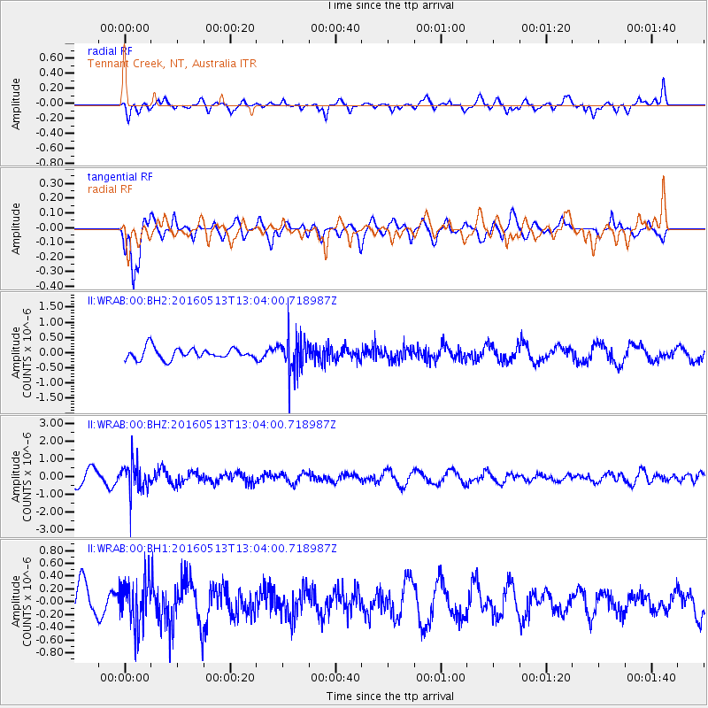
WRAB Tennant Creek, NT, Australia - Earthquake Result Viewer
*The percent match for this event was below the threshold and hence no stack was calculated.
| Earthquake location: |
South Of Fiji Islands |
| Earthquake latitude/longitude: |
-25.5/179.3 |
| Earthquake time(UTC): |
2016/05/13 (134) 12:57:27 GMT |
| Earthquake Depth: |
506 km |
| Earthquake Magnitude: |
5.6 MWW |
| Earthquake Catalog/Contributor: |
NEIC PDE/NEIC COMCAT |
|
| Network: |
II Global Seismograph Network (GSN - IRIS/IDA) |
| Station: |
WRAB Tennant Creek, NT, Australia |
| Lat/Lon: |
19.93 S/134.36 E |
| Elevation: |
366 m |
|
| Distance: |
41.7 deg |
| Az: |
268.142 deg |
| Baz: |
106.222 deg |
| Ray Param: |
$rayparam |
*The percent match for this event was below the threshold and hence was not used in the summary stack. |
|
| Radial Match: |
68.52646 % |
| Radial Bump: |
400 |
| Transverse Match: |
74.45469 % |
| Transverse Bump: |
400 |
| SOD ConfigId: |
1609551 |
| Insert Time: |
2016-06-23 12:24:07.377 +0000 |
| GWidth: |
2.5 |
| Max Bumps: |
400 |
| Tol: |
0.001 |
|
Signal To Noise
| Channel | StoN | STA | LTA |
| II:WRAB:00:BHZ:20160513T13:04:00.718987Z | 1.8573889 | 8.4584633E-7 | 4.553954E-7 |
| II:WRAB:00:BH1:20160513T13:04:00.718987Z | 1.2298723 | 3.6817136E-7 | 2.9935737E-7 |
| II:WRAB:00:BH2:20160513T13:04:00.718987Z | 3.279683 | 5.986654E-7 | 1.8253758E-7 |
| Arrivals |
| Ps | |
| PpPs | |
| PsPs/PpSs | |


