You are here: Home > Network List > TA - USArray Transportable Network (new EarthScope stations) Stations List
> Station H16K Elim, AK, USA > Earthquake Result Viewer
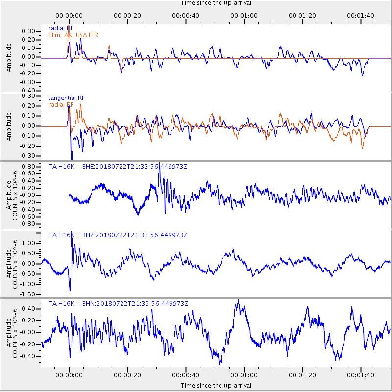
H16K Elim, AK, USA - Earthquake Result Viewer
*The percent match for this event was below the threshold and hence no stack was calculated.
| Earthquake location: |
Vanuatu Islands |
| Earthquake latitude/longitude: |
-18.9/168.9 |
| Earthquake time(UTC): |
2018/07/22 (203) 21:21:57 GMT |
| Earthquake Depth: |
100 km |
| Earthquake Magnitude: |
5.5 Mww |
| Earthquake Catalog/Contributor: |
NEIC PDE/us |
|
| Network: |
TA USArray Transportable Network (new EarthScope stations) |
| Station: |
H16K Elim, AK, USA |
| Lat/Lon: |
64.64 N/162.24 W |
| Elevation: |
216 m |
|
| Distance: |
86.2 deg |
| Az: |
12.02 deg |
| Baz: |
207.239 deg |
| Ray Param: |
$rayparam |
*The percent match for this event was below the threshold and hence was not used in the summary stack. |
|
| Radial Match: |
45.59419 % |
| Radial Bump: |
400 |
| Transverse Match: |
79.80847 % |
| Transverse Bump: |
400 |
| SOD ConfigId: |
13570011 |
| Insert Time: |
2019-04-30 15:40:57.310 +0000 |
| GWidth: |
2.5 |
| Max Bumps: |
400 |
| Tol: |
0.001 |
|
Signal To Noise
| Channel | StoN | STA | LTA |
| TA:H16K: :BHZ:20180722T21:33:56.449973Z | 4.604326 | 6.1436793E-7 | 1.3343276E-7 |
| TA:H16K: :BHN:20180722T21:33:56.449973Z | 0.8552395 | 1.6917438E-7 | 1.9780937E-7 |
| TA:H16K: :BHE:20180722T21:33:56.449973Z | 1.8913399 | 3.631802E-7 | 1.920227E-7 |
| Arrivals |
| Ps | |
| PpPs | |
| PsPs/PpSs | |


