You are here: Home > Network List > TA - USArray Transportable Network (new EarthScope stations) Stations List
> Station 224A Corundas Mountain, Dell City, TX, USA > Earthquake Result Viewer
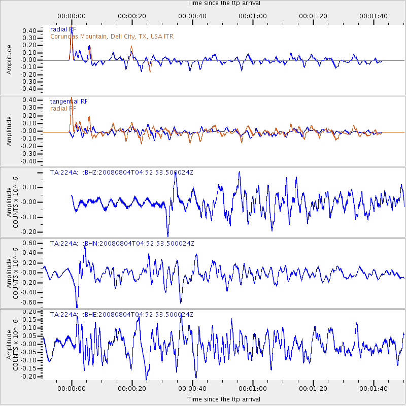
224A Corundas Mountain, Dell City, TX, USA - Earthquake Result Viewer
*The percent match for this event was below the threshold and hence no stack was calculated.
| Earthquake location: |
Kuril Islands |
| Earthquake latitude/longitude: |
49.9/156.4 |
| Earthquake time(UTC): |
2008/08/04 (217) 04:42:14 GMT |
| Earthquake Depth: |
77 km |
| Earthquake Magnitude: |
5.6 MB, 5.8 MW, 5.7 MW |
| Earthquake Catalog/Contributor: |
WHDF/NEIC |
|
| Network: |
TA USArray Transportable Network (new EarthScope stations) |
| Station: |
224A Corundas Mountain, Dell City, TX, USA |
| Lat/Lon: |
32.08 N/105.52 W |
| Elevation: |
1487 m |
|
| Distance: |
71.0 deg |
| Az: |
62.731 deg |
| Baz: |
317.333 deg |
| Ray Param: |
$rayparam |
*The percent match for this event was below the threshold and hence was not used in the summary stack. |
|
| Radial Match: |
75.106926 % |
| Radial Bump: |
377 |
| Transverse Match: |
61.991726 % |
| Transverse Bump: |
400 |
| SOD ConfigId: |
2504 |
| Insert Time: |
2010-03-06 13:06:40.874 +0000 |
| GWidth: |
2.5 |
| Max Bumps: |
400 |
| Tol: |
0.001 |
|
Signal To Noise
| Channel | StoN | STA | LTA |
| TA:224A: :BHN:20080804T04:52:53.500024Z | 4.674667 | 3.190048E-7 | 6.8241185E-8 |
| TA:224A: :BHE:20080804T04:52:53.500024Z | 1.793706 | 8.065749E-8 | 4.4966953E-8 |
| TA:224A: :BHZ:20080804T04:52:53.500024Z | 4.5835514 | 1.04091995E-7 | 2.27099E-8 |
| Arrivals |
| Ps | |
| PpPs | |
| PsPs/PpSs | |


