You are here: Home > Network List > TA - USArray Transportable Network (new EarthScope stations) Stations List
> Station 224A Corundas Mountain, Dell City, TX, USA > Earthquake Result Viewer
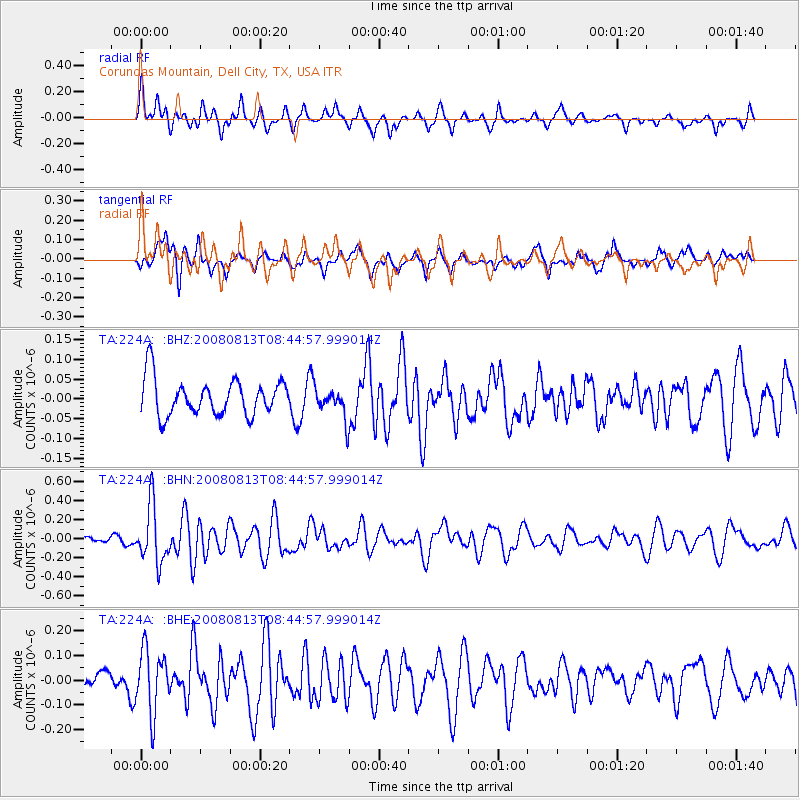
224A Corundas Mountain, Dell City, TX, USA - Earthquake Result Viewer
*The percent match for this event was below the threshold and hence no stack was calculated.
| Earthquake location: |
North Of Severnaya Zemlya |
| Earthquake latitude/longitude: |
83.6/115.2 |
| Earthquake time(UTC): |
2008/08/13 (226) 08:35:02 GMT |
| Earthquake Depth: |
10 km |
| Earthquake Magnitude: |
5.5 MB, 4.7 MS, 5.4 MW, 5.4 MW |
| Earthquake Catalog/Contributor: |
WHDF/NEIC |
|
| Network: |
TA USArray Transportable Network (new EarthScope stations) |
| Station: |
224A Corundas Mountain, Dell City, TX, USA |
| Lat/Lon: |
32.08 N/105.52 W |
| Elevation: |
1487 m |
|
| Distance: |
63.0 deg |
| Az: |
38.462 deg |
| Baz: |
355.314 deg |
| Ray Param: |
$rayparam |
*The percent match for this event was below the threshold and hence was not used in the summary stack. |
|
| Radial Match: |
70.80769 % |
| Radial Bump: |
400 |
| Transverse Match: |
58.12341 % |
| Transverse Bump: |
366 |
| SOD ConfigId: |
2504 |
| Insert Time: |
2010-03-06 13:06:42.727 +0000 |
| GWidth: |
2.5 |
| Max Bumps: |
400 |
| Tol: |
0.001 |
|
Signal To Noise
| Channel | StoN | STA | LTA |
| TA:224A: :BHN:20080813T08:44:57.999014Z | 6.059039 | 3.005255E-7 | 4.959953E-8 |
| TA:224A: :BHE:20080813T08:44:57.999014Z | 2.6651418 | 1.2558627E-7 | 4.7121794E-8 |
| TA:224A: :BHZ:20080813T08:44:57.999014Z | 0.8382113 | 3.8396735E-8 | 4.580794E-8 |
| Arrivals |
| Ps | |
| PpPs | |
| PsPs/PpSs | |


