You are here: Home > Network List > CI - Caltech Regional Seismic Network Stations List
> Station PHL Parkhill, California, USA > Earthquake Result Viewer
PHL Parkhill, California, USA - Earthquake Result Viewer

| Earthquake location: |
Alaska Peninsula |
| Earthquake latitude/longitude: |
56.8/-158.3 |
| Earthquake time(UTC): |
2000/12/22 (357) 00:40:36 GMT |
| Earthquake Depth: |
106 km |
| Earthquake Magnitude: |
5.4 MB, 5.5 MW |
| Earthquake Catalog/Contributor: |
WHDF/NEIC |
|
| Network: |
CI Caltech Regional Seismic Network |
| Station: |
PHL Parkhill, California, USA |
| Lat/Lon: |
35.41 N/120.55 W |
| Elevation: |
351 m |
|
| Distance: |
33.2 deg |
| Az: |
113.915 deg |
| Baz: |
322.025 deg |
| Ray Param: |
0.07801304 |
| Estimated Moho Depth: |
29.75 km |
| Estimated Crust Vp/Vs: |
2.08 |
| Assumed Crust Vp: |
6.183 km/s |
| Estimated Crust Vs: |
2.972 km/s |
| Estimated Crust Poisson's Ratio: |
0.35 |
|
| Radial Match: |
80.93779 % |
| Radial Bump: |
400 |
| Transverse Match: |
70.39944 % |
| Transverse Bump: |
400 |
| SOD ConfigId: |
3770 |
| Insert Time: |
2010-02-26 02:06:36.695 +0000 |
| GWidth: |
2.5 |
| Max Bumps: |
400 |
| Tol: |
0.001 |
|
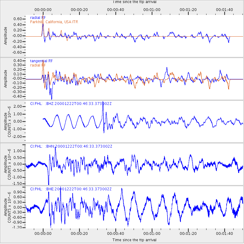
Signal To Noise
| Channel | StoN | STA | LTA |
| CI:PHL: :BHN:20001222T00:46:33.373002Z | 2.1395183 | 4.8622474E-7 | 2.2725897E-7 |
| CI:PHL: :BHE:20001222T00:46:33.373002Z | 1.088433 | 4.558517E-7 | 4.1881466E-7 |
| CI:PHL: :BHZ:20001222T00:46:33.373002Z | 1.5710174 | 9.315027E-7 | 5.929296E-7 |
| Arrivals |
| Ps | 5.5 SECOND |
| PpPs | 14 SECOND |
| PsPs/PpSs | 19 SECOND |


