You are here: Home > Network List > CI - Caltech Regional Seismic Network Stations List
> Station PHL Parkhill, California, USA > Earthquake Result Viewer
PHL Parkhill, California, USA - Earthquake Result Viewer
| Earthquake location: |
New Ireland Region, P.N.G. |
| Earthquake latitude/longitude: |
-5.2/153.1 |
| Earthquake time(UTC): |
2000/11/16 (321) 08:12:20 GMT |
| Earthquake Depth: |
33 km |
| Earthquake Magnitude: |
5.5 MB |
| Earthquake Catalog/Contributor: |
WHDF/NEIC |
|
| Network: |
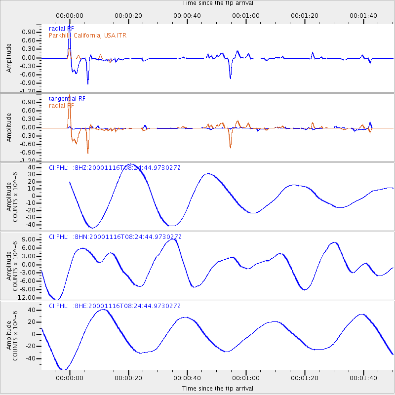
CI Caltech Regional Seismic Network |
| Station: |
PHL Parkhill, California, USA |
| Lat/Lon: |
35.41 N/120.55 W |
| Elevation: |
351 m |
|
| Distance: |
90.0 deg |
| Az: |
54.606 deg |
| Baz: |
263.635 deg |
| Ray Param: |
0.041700922 |
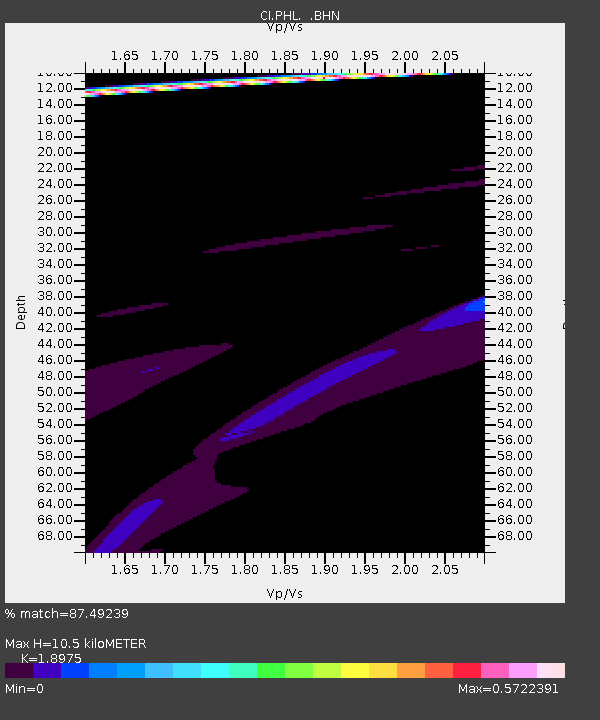
| Estimated Moho Depth: |
10.5 km |
| Estimated Crust Vp/Vs: |
1.90 |
| Assumed Crust Vp: |
6.183 km/s |
| Estimated Crust Vs: |
3.258 km/s |
| Estimated Crust Poisson's Ratio: |
0.31 |
|
| Radial Match: |
87.49239 % |
| Radial Bump: |
400 |
| Transverse Match: |
56.512093 % |
| Transverse Bump: |
400 |
| SOD ConfigId: |
3770 |
| Insert Time: |
2010-02-26 02:06:37.585 +0000 |
| GWidth: |
2.5 |
| Max Bumps: |
400 |
| Tol: |
0.001 |
|
Signal To Noise
| Channel | StoN | STA | LTA |
| CI:PHL: :BHN:20001116T08:24:44.973027Z | 0.5601323 | 4.8326215E-6 | 8.627642E-6 |
| CI:PHL: :BHE:20001116T08:24:44.973027Z | 1.0455726 | 3.7805636E-5 | 3.6157824E-5 |
| CI:PHL: :BHZ:20001116T08:24:44.973027Z | 1.0449557 | 3.3308937E-5 | 3.1875934E-5 |
| Arrivals |
| Ps | 1.6 SECOND |
| PpPs | 4.8 SECOND |
| PsPs/PpSs | 6.4 SECOND |


