You are here: Home > Network List > CI - Caltech Regional Seismic Network Stations List
> Station PHL Parkhill, California, USA > Earthquake Result Viewer
PHL Parkhill, California, USA - Earthquake Result Viewer
| Earthquake location: |
New Ireland Region, P.N.G. |
| Earthquake latitude/longitude: |
-4.5/153.7 |
| Earthquake time(UTC): |
2000/11/16 (321) 05:51:51 GMT |
| Earthquake Depth: |
33 km |
| Earthquake Magnitude: |
5.8 MB |
| Earthquake Catalog/Contributor: |
WHDF/NEIC |
|
| Network: |
CI Caltech Regional Seismic Network |
| Station: |
PHL Parkhill, California, USA |
| Lat/Lon: |
35.41 N/120.55 W |
| Elevation: |
351 m |
|
| Distance: |
89.1 deg |
| Az: |
54.56 deg |
| Baz: |
263.9 deg |
| Ray Param: |
0.04204314 |
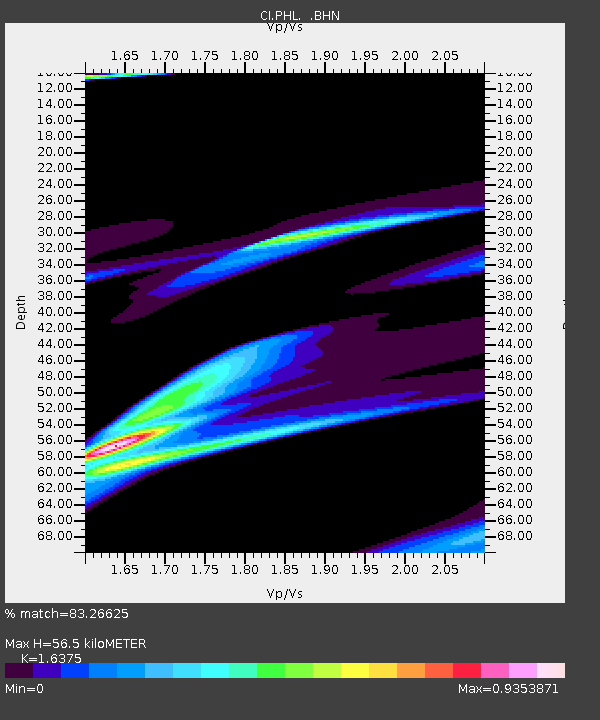
| Estimated Moho Depth: |
56.5 km |
| Estimated Crust Vp/Vs: |
1.64 |
| Assumed Crust Vp: |
6.183 km/s |
| Estimated Crust Vs: |
3.776 km/s |
| Estimated Crust Poisson's Ratio: |
0.20 |
|
| Radial Match: |
83.26625 % |
| Radial Bump: |
400 |
| Transverse Match: |
87.57902 % |
| Transverse Bump: |
252 |
| SOD ConfigId: |
3770 |
| Insert Time: |
2010-02-26 02:06:39.657 +0000 |
| GWidth: |
2.5 |
| Max Bumps: |
400 |
| Tol: |
0.001 |
|
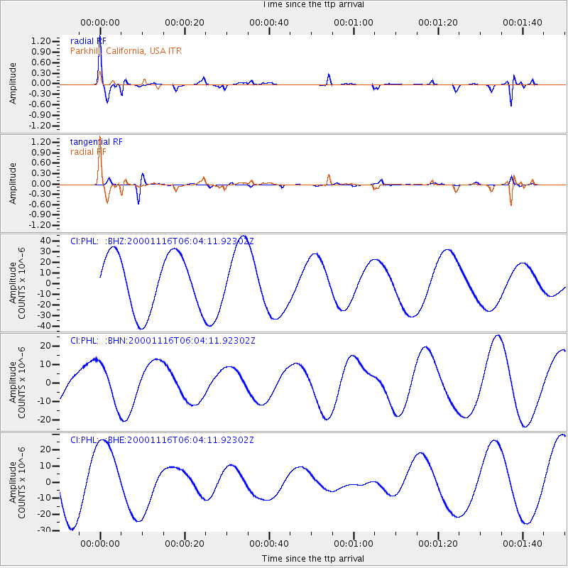
Signal To Noise
| Channel | StoN | STA | LTA |
| CI:PHL: :BHN:20001116T06:04:11.92302Z | 1.541243 | 1.1082154E-5 | 7.1904005E-6 |
| CI:PHL: :BHE:20001116T06:04:11.92302Z | 0.819058 | 2.1675782E-5 | 2.646428E-5 |
| CI:PHL: :BHZ:20001116T06:04:11.92302Z | 1.1560054 | 2.9978853E-5 | 2.5933143E-5 |
| Arrivals |
| Ps | 6.0 SECOND |
| PpPs | 24 SECOND |
| PsPs/PpSs | 30 SECOND |


