You are here: Home > Network List > TA - USArray Transportable Network (new EarthScope stations) Stations List
> Station M53A WI Miller and Sons, Farmdale, OH, USA > Earthquake Result Viewer
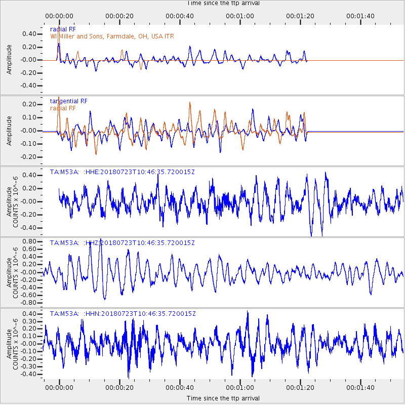
M53A WI Miller and Sons, Farmdale, OH, USA - Earthquake Result Viewer
*The percent match for this event was below the threshold and hence no stack was calculated.
| Earthquake location: |
Central Mid-Atlantic Ridge |
| Earthquake latitude/longitude: |
-0.3/-19.2 |
| Earthquake time(UTC): |
2018/07/23 (204) 10:36:00 GMT |
| Earthquake Depth: |
10 km |
| Earthquake Magnitude: |
5.9 Mww |
| Earthquake Catalog/Contributor: |
NEIC PDE/us |
|
| Network: |
TA USArray Transportable Network (new EarthScope stations) |
| Station: |
M53A WI Miller and Sons, Farmdale, OH, USA |
| Lat/Lon: |
41.44 N/80.68 W |
| Elevation: |
334 m |
|
| Distance: |
69.2 deg |
| Az: |
315.048 deg |
| Baz: |
110.004 deg |
| Ray Param: |
$rayparam |
*The percent match for this event was below the threshold and hence was not used in the summary stack. |
|
| Radial Match: |
68.26113 % |
| Radial Bump: |
400 |
| Transverse Match: |
47.06927 % |
| Transverse Bump: |
383 |
| SOD ConfigId: |
13570011 |
| Insert Time: |
2019-04-30 16:03:46.820 +0000 |
| GWidth: |
2.5 |
| Max Bumps: |
400 |
| Tol: |
0.001 |
|
Signal To Noise
| Channel | StoN | STA | LTA |
| TA:M53A: :HHZ:20180723T10:46:35.720015Z | 2.0919034 | 2.6815692E-7 | 1.28188E-7 |
| TA:M53A: :HHN:20180723T10:46:35.720015Z | 0.9680758 | 1.3286352E-7 | 1.3724495E-7 |
| TA:M53A: :HHE:20180723T10:46:35.720015Z | 1.3277109 | 1.595655E-7 | 1.2018091E-7 |
| Arrivals |
| Ps | |
| PpPs | |
| PsPs/PpSs | |


