You are here: Home > Network List > TA - USArray Transportable Network (new EarthScope stations) Stations List
> Station F19A Roth Fram, Molt, MT, USA > Earthquake Result Viewer
F19A Roth Fram, Molt, MT, USA - Earthquake Result Viewer
| Earthquake location: |
Hokkaido, Japan Region |
| Earthquake latitude/longitude: |
41.9/143.8 |
| Earthquake time(UTC): |
2008/09/11 (255) 00:20:50 GMT |
| Earthquake Depth: |
25 km |
| Earthquake Magnitude: |
6.1 MB, 7.0 MS, 6.8 MW, 6.8 MW |
| Earthquake Catalog/Contributor: |
WHDF/NEIC |
|
| Network: |
TA USArray Transportable Network (new EarthScope stations) |
| Station: |
F19A Roth Fram, Molt, MT, USA |
| Lat/Lon: |
45.85 N/108.94 W |
| Elevation: |
1243 m |
|
| Distance: |
71.3 deg |
| Az: |
44.786 deg |
| Baz: |
311.187 deg |
| Ray Param: |
0.05438849 |
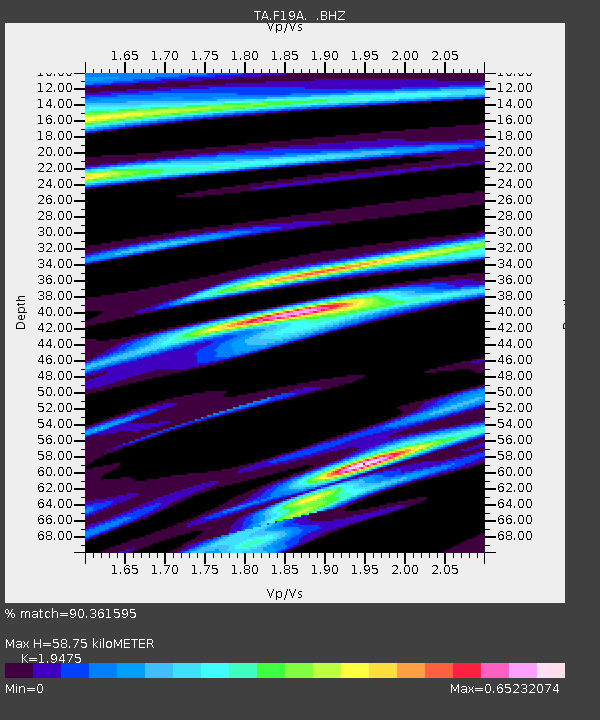
| Estimated Moho Depth: |
58.75 km |
| Estimated Crust Vp/Vs: |
1.95 |
| Assumed Crust Vp: |
6.242 km/s |
| Estimated Crust Vs: |
3.205 km/s |
| Estimated Crust Poisson's Ratio: |
0.32 |
|
| Radial Match: |
90.361595 % |
| Radial Bump: |
331 |
| Transverse Match: |
75.05067 % |
| Transverse Bump: |
364 |
| SOD ConfigId: |
2560 |
| Insert Time: |
2010-03-06 13:08:55.241 +0000 |
| GWidth: |
2.5 |
| Max Bumps: |
400 |
| Tol: |
0.001 |
|
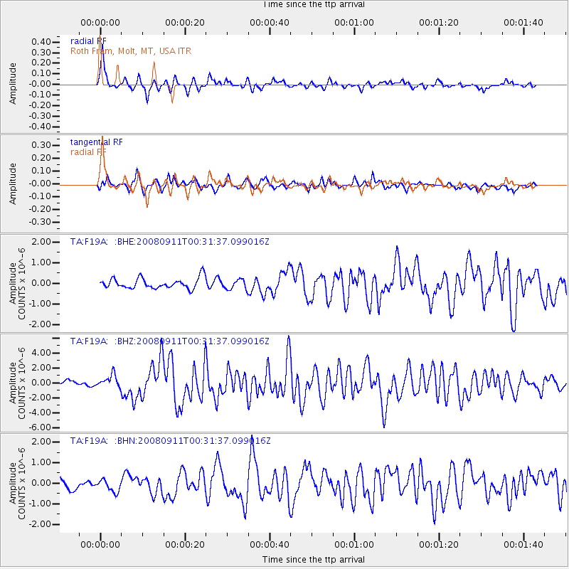
Signal To Noise
| Channel | StoN | STA | LTA |
| TA:F19A: :BHZ:20080911T00:31:37.099016Z | 2.7664726 | 8.889152E-7 | 3.213172E-7 |
| TA:F19A: :BHN:20080911T00:31:37.099016Z | 1.0051224 | 2.9504756E-7 | 2.9354388E-7 |
| TA:F19A: :BHE:20080911T00:31:37.099016Z | 0.9842614 | 2.5039697E-7 | 2.5440087E-7 |
| Arrivals |
| Ps | 9.2 SECOND |
| PpPs | 27 SECOND |
| PsPs/PpSs | 36 SECOND |


