You are here: Home > Network List > TA - USArray Transportable Network (new EarthScope stations) Stations List
> Station F19A Roth Fram, Molt, MT, USA > Earthquake Result Viewer
F19A Roth Fram, Molt, MT, USA - Earthquake Result Viewer
| Earthquake location: |
Southeast Of Honshu, Japan |
| Earthquake latitude/longitude: |
32.8/140.4 |
| Earthquake time(UTC): |
2009/08/12 (224) 22:48:51 GMT |
| Earthquake Depth: |
53 km |
| Earthquake Magnitude: |
6.2 MB, 6.6 MW, 6.6 MW |
| Earthquake Catalog/Contributor: |
WHDF/NEIC |
|
| Network: |
TA USArray Transportable Network (new EarthScope stations) |
| Station: |
F19A Roth Fram, Molt, MT, USA |
| Lat/Lon: |
45.85 N/108.94 W |
| Elevation: |
1243 m |
|
| Distance: |
79.7 deg |
| Az: |
41.65 deg |
| Baz: |
306.805 deg |
| Ray Param: |
0.04865935 |
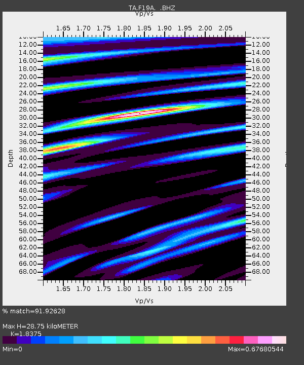
| Estimated Moho Depth: |
28.75 km |
| Estimated Crust Vp/Vs: |
1.84 |
| Assumed Crust Vp: |
6.242 km/s |
| Estimated Crust Vs: |
3.397 km/s |
| Estimated Crust Poisson's Ratio: |
0.29 |
|
| Radial Match: |
91.92628 % |
| Radial Bump: |
393 |
| Transverse Match: |
86.95091 % |
| Transverse Bump: |
337 |
| SOD ConfigId: |
2622 |
| Insert Time: |
2010-03-06 13:08:59.925 +0000 |
| GWidth: |
2.5 |
| Max Bumps: |
400 |
| Tol: |
0.001 |
|

Signal To Noise
| Channel | StoN | STA | LTA |
| TA:F19A: :BHZ:20090812T23:00:22.649004Z | 39.304966 | 2.7963665E-6 | 7.114537E-8 |
| TA:F19A: :BHN:20090812T23:00:22.649004Z | 7.4716754 | 5.422492E-7 | 7.257398E-8 |
| TA:F19A: :BHE:20090812T23:00:22.649004Z | 9.871224 | 7.402619E-7 | 7.49919E-8 |
| Arrivals |
| Ps | 4.0 SECOND |
| PpPs | 13 SECOND |
| PsPs/PpSs | 17 SECOND |


