You are here: Home > Network List > IU - Global Seismograph Network (GSN - IRIS/USGS) Stations List
> Station JOHN Johnston Island, USA > Earthquake Result Viewer
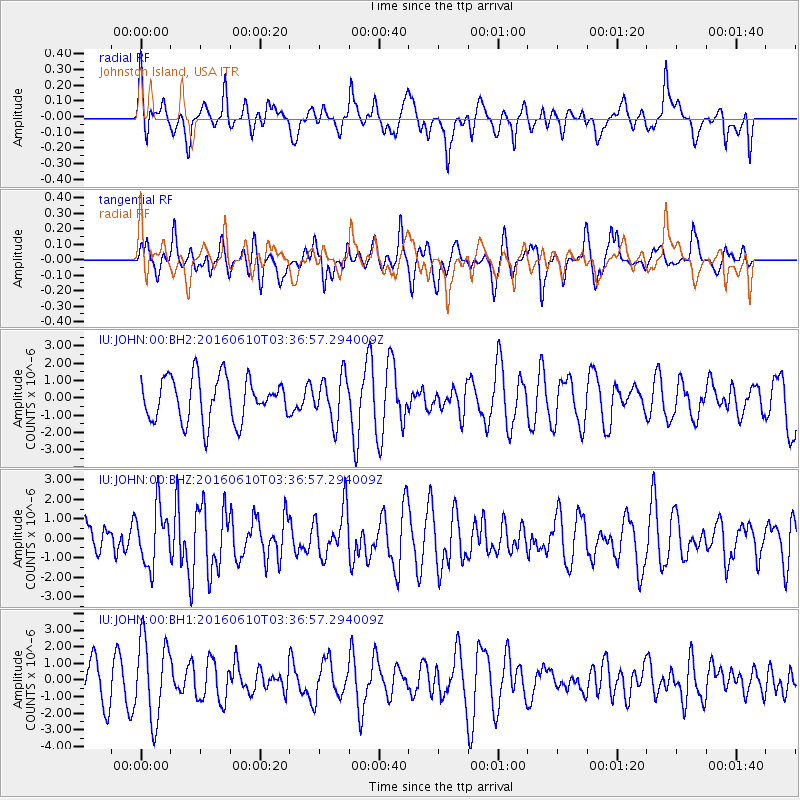
JOHN Johnston Island, USA - Earthquake Result Viewer
*The percent match for this event was below the threshold and hence no stack was calculated.
| Earthquake location: |
Near Coast Of Nicaragua |
| Earthquake latitude/longitude: |
12.8/-87.0 |
| Earthquake time(UTC): |
2016/06/10 (162) 03:25:22 GMT |
| Earthquake Depth: |
10 km |
| Earthquake Magnitude: |
6.1 MWP |
| Earthquake Catalog/Contributor: |
NEIC PDE/NEIC COMCAT |
|
| Network: |
IU Global Seismograph Network (GSN - IRIS/USGS) |
| Station: |
JOHN Johnston Island, USA |
| Lat/Lon: |
16.73 N/169.53 W |
| Elevation: |
2.0 m |
|
| Distance: |
79.3 deg |
| Az: |
284.829 deg |
| Baz: |
79.728 deg |
| Ray Param: |
$rayparam |
*The percent match for this event was below the threshold and hence was not used in the summary stack. |
|
| Radial Match: |
46.285072 % |
| Radial Bump: |
400 |
| Transverse Match: |
57.316906 % |
| Transverse Bump: |
400 |
| SOD ConfigId: |
1609551 |
| Insert Time: |
2016-06-24 03:25:41.817 +0000 |
| GWidth: |
2.5 |
| Max Bumps: |
400 |
| Tol: |
0.001 |
|
Signal To Noise
| Channel | StoN | STA | LTA |
| IU:JOHN:00:BHZ:20160610T03:36:57.294009Z | 1.5974791 | 1.4732012E-6 | 9.222038E-7 |
| IU:JOHN:00:BH1:20160610T03:36:57.294009Z | 2.2439249 | 2.4280732E-6 | 1.0820653E-6 |
| IU:JOHN:00:BH2:20160610T03:36:57.294009Z | 1.0416795 | 1.2998023E-6 | 1.2477948E-6 |
| Arrivals |
| Ps | |
| PpPs | |
| PsPs/PpSs | |


