You are here: Home > Network List > TA - USArray Transportable Network (new EarthScope stations) Stations List
> Station F19A Roth Fram, Molt, MT, USA > Earthquake Result Viewer
F19A Roth Fram, Molt, MT, USA - Earthquake Result Viewer
| Earthquake location: |
Kuril Islands |
| Earthquake latitude/longitude: |
48.3/154.2 |
| Earthquake time(UTC): |
2009/09/10 (253) 02:46:50 GMT |
| Earthquake Depth: |
36 km |
| Earthquake Magnitude: |
6.0 MB, 5.5 MS, 6.0 MW, 5.8 MW |
| Earthquake Catalog/Contributor: |
WHDF/NEIC |
|
| Network: |
TA USArray Transportable Network (new EarthScope stations) |
| Station: |
F19A Roth Fram, Molt, MT, USA |
| Lat/Lon: |
45.85 N/108.94 W |
| Elevation: |
1243 m |
|
| Distance: |
61.5 deg |
| Az: |
52.129 deg |
| Baz: |
311.068 deg |
| Ray Param: |
0.060757395 |
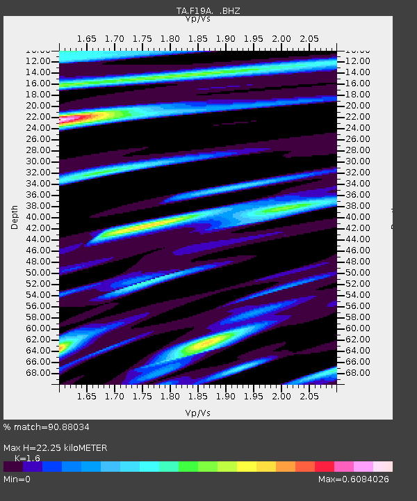
| Estimated Moho Depth: |
22.25 km |
| Estimated Crust Vp/Vs: |
1.60 |
| Assumed Crust Vp: |
6.242 km/s |
| Estimated Crust Vs: |
3.901 km/s |
| Estimated Crust Poisson's Ratio: |
0.18 |
|
| Radial Match: |
90.88034 % |
| Radial Bump: |
400 |
| Transverse Match: |
88.46677 % |
| Transverse Bump: |
400 |
| SOD ConfigId: |
2622 |
| Insert Time: |
2010-03-06 13:09:06.134 +0000 |
| GWidth: |
2.5 |
| Max Bumps: |
400 |
| Tol: |
0.001 |
|
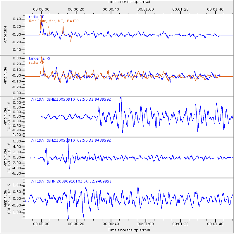
Signal To Noise
| Channel | StoN | STA | LTA |
| TA:F19A: :BHZ:20090910T02:56:32.948999Z | 18.915054 | 1.5305378E-6 | 8.091638E-8 |
| TA:F19A: :BHN:20090910T02:56:32.948999Z | 1.5291252 | 2.0645793E-7 | 1.3501702E-7 |
| TA:F19A: :BHE:20090910T02:56:32.948999Z | 3.2695606 | 2.9831267E-7 | 9.123937E-8 |
| Arrivals |
| Ps | 2.2 SECOND |
| PpPs | 8.8 SECOND |
| PsPs/PpSs | 11 SECOND |


