You are here: Home > Network List > TA - USArray Transportable Network (new EarthScope stations) Stations List
> Station F19A Roth Fram, Molt, MT, USA > Earthquake Result Viewer
F19A Roth Fram, Molt, MT, USA - Earthquake Result Viewer
| Earthquake location: |
East Of Severnaya Zemlya |
| Earthquake latitude/longitude: |
81.6/119.5 |
| Earthquake time(UTC): |
2009/10/07 (280) 20:52:13 GMT |
| Earthquake Depth: |
8.0 km |
| Earthquake Magnitude: |
5.7 MB, 5.1 MS, 5.8 MW, 5.8 MW |
| Earthquake Catalog/Contributor: |
WHDF/NEIC |
|
| Network: |
TA USArray Transportable Network (new EarthScope stations) |
| Station: |
F19A Roth Fram, Molt, MT, USA |
| Lat/Lon: |
45.85 N/108.94 W |
| Elevation: |
1243 m |
|
| Distance: |
50.3 deg |
| Az: |
42.866 deg |
| Baz: |
351.744 deg |
| Ray Param: |
0.06816876 |
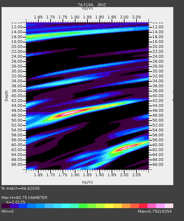
| Estimated Moho Depth: |
60.75 km |
| Estimated Crust Vp/Vs: |
2.01 |
| Assumed Crust Vp: |
6.242 km/s |
| Estimated Crust Vs: |
3.102 km/s |
| Estimated Crust Poisson's Ratio: |
0.34 |
|
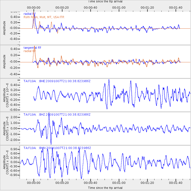
| Radial Match: |
86.62008 % |
| Radial Bump: |
400 |
| Transverse Match: |
69.95244 % |
| Transverse Bump: |
400 |
| SOD ConfigId: |
2622 |
| Insert Time: |
2010-03-06 13:09:08.502 +0000 |
| GWidth: |
2.5 |
| Max Bumps: |
400 |
| Tol: |
0.001 |
|
Signal To Noise
| Channel | StoN | STA | LTA |
| TA:F19A: :BHZ:20091007T21:00:38.823986Z | 9.767242 | 7.0972067E-7 | 7.266336E-8 |
| TA:F19A: :BHN:20091007T21:00:38.823986Z | 4.3861184 | 4.6159795E-7 | 1.05240645E-7 |
| TA:F19A: :BHE:20091007T21:00:38.823986Z | 0.84393823 | 1.1582289E-7 | 1.3724096E-7 |
| Arrivals |
| Ps | 10 SECOND |
| PpPs | 28 SECOND |
| PsPs/PpSs | 38 SECOND |


