You are here: Home > Network List > TA - USArray Transportable Network (new EarthScope stations) Stations List
> Station F19A Roth Fram, Molt, MT, USA > Earthquake Result Viewer
F19A Roth Fram, Molt, MT, USA - Earthquake Result Viewer
| Earthquake location: |
Kermadec Islands Region |
| Earthquake latitude/longitude: |
-27.4/-176.3 |
| Earthquake time(UTC): |
2009/02/18 (049) 21:53:45 GMT |
| Earthquake Depth: |
25 km |
| Earthquake Magnitude: |
6.8 MB, 7.2 MS, 6.9 MW, 6.9 MW |
| Earthquake Catalog/Contributor: |
WHDF/NEIC |
|
| Network: |
TA USArray Transportable Network (new EarthScope stations) |
| Station: |
F19A Roth Fram, Molt, MT, USA |
| Lat/Lon: |
45.85 N/108.94 W |
| Elevation: |
1243 m |
|
| Distance: |
95.1 deg |
| Az: |
40.37 deg |
| Baz: |
235.467 deg |
| Ray Param: |
0.040864453 |
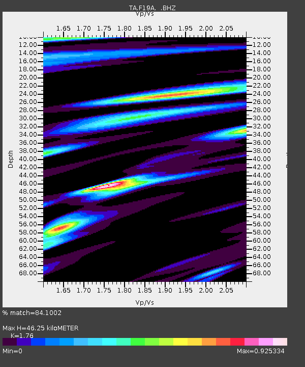
| Estimated Moho Depth: |
46.25 km |
| Estimated Crust Vp/Vs: |
1.76 |
| Assumed Crust Vp: |
6.242 km/s |
| Estimated Crust Vs: |
3.547 km/s |
| Estimated Crust Poisson's Ratio: |
0.26 |
|
| Radial Match: |
84.1002 % |
| Radial Bump: |
400 |
| Transverse Match: |
84.49783 % |
| Transverse Bump: |
400 |
| SOD ConfigId: |
2658 |
| Insert Time: |
2010-03-06 13:09:16.442 +0000 |
| GWidth: |
2.5 |
| Max Bumps: |
400 |
| Tol: |
0.001 |
|

Signal To Noise
| Channel | StoN | STA | LTA |
| TA:F19A: :BHZ:20090218T22:06:34.350002Z | 2.1523638 | 7.806171E-7 | 3.6267897E-7 |
| TA:F19A: :BHN:20090218T22:06:34.350002Z | 1.3859723 | 4.2901578E-7 | 3.095414E-7 |
| TA:F19A: :BHE:20090218T22:06:34.350002Z | 1.0673124 | 4.3918823E-7 | 4.1148988E-7 |
| Arrivals |
| Ps | 5.7 SECOND |
| PpPs | 20 SECOND |
| PsPs/PpSs | 26 SECOND |


