You are here: Home > Network List > TA - USArray Transportable Network (new EarthScope stations) Stations List
> Station F19A Roth Fram, Molt, MT, USA > Earthquake Result Viewer
F19A Roth Fram, Molt, MT, USA - Earthquake Result Viewer
| Earthquake location: |
North Of Honduras |
| Earthquake latitude/longitude: |
16.7/-86.2 |
| Earthquake time(UTC): |
2009/05/28 (148) 08:24:45 GMT |
| Earthquake Depth: |
10 km |
| Earthquake Magnitude: |
6.7 MB, 7.2 MS, 7.3 MW, 7.3 MW |
| Earthquake Catalog/Contributor: |
WHDF/NEIC |
|
| Network: |
TA USArray Transportable Network (new EarthScope stations) |
| Station: |
F19A Roth Fram, Molt, MT, USA |
| Lat/Lon: |
45.85 N/108.94 W |
| Elevation: |
1243 m |
|
| Distance: |
34.7 deg |
| Az: |
331.695 deg |
| Baz: |
139.449 deg |
| Ray Param: |
0.07761403 |
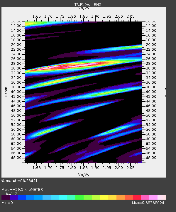
| Estimated Moho Depth: |
29.5 km |
| Estimated Crust Vp/Vs: |
1.70 |
| Assumed Crust Vp: |
6.242 km/s |
| Estimated Crust Vs: |
3.672 km/s |
| Estimated Crust Poisson's Ratio: |
0.24 |
|
| Radial Match: |
96.25641 % |
| Radial Bump: |
380 |
| Transverse Match: |
88.03756 % |
| Transverse Bump: |
400 |
| SOD ConfigId: |
2648 |
| Insert Time: |
2010-03-06 13:09:18.489 +0000 |
| GWidth: |
2.5 |
| Max Bumps: |
400 |
| Tol: |
0.001 |
|
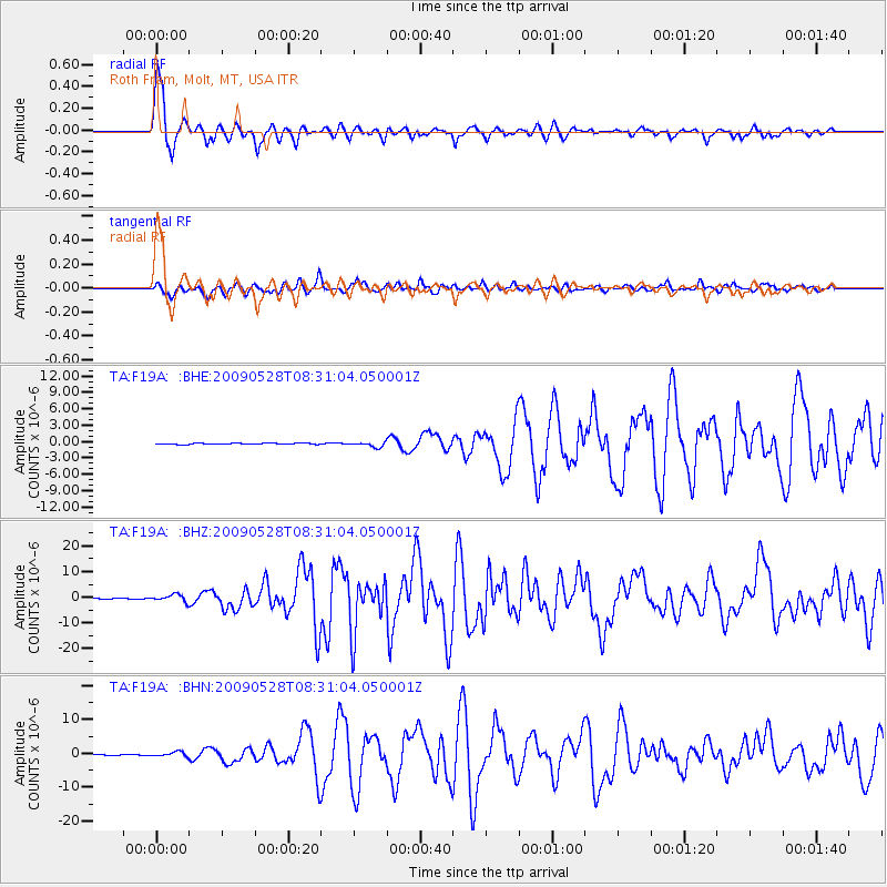
Signal To Noise
| Channel | StoN | STA | LTA |
| TA:F19A: :BHZ:20090528T08:31:04.050001Z | 14.237803 | 1.335908E-6 | 9.3828234E-8 |
| TA:F19A: :BHN:20090528T08:31:04.050001Z | 7.2928796 | 6.56941E-7 | 9.007978E-8 |
| TA:F19A: :BHE:20090528T08:31:04.050001Z | 3.9199402 | 4.486421E-7 | 1.1445127E-7 |
| Arrivals |
| Ps | 3.6 SECOND |
| PpPs | 12 SECOND |
| PsPs/PpSs | 15 SECOND |


