You are here: Home > Network List > TA - USArray Transportable Network (new EarthScope stations) Stations List
> Station F19A Roth Fram, Molt, MT, USA > Earthquake Result Viewer
F19A Roth Fram, Molt, MT, USA - Earthquake Result Viewer

| Earthquake location: |
Northern Mid-Atlantic Ridge |
| Earthquake latitude/longitude: |
23.9/-46.1 |
| Earthquake time(UTC): |
2009/06/06 (157) 20:33:28 GMT |
| Earthquake Depth: |
14 km |
| Earthquake Magnitude: |
6.0 MB, 5.7 MS, 6.0 MW, 6.0 MW |
| Earthquake Catalog/Contributor: |
WHDF/NEIC |
|
| Network: |
TA USArray Transportable Network (new EarthScope stations) |
| Station: |
F19A Roth Fram, Molt, MT, USA |
| Lat/Lon: |
45.85 N/108.94 W |
| Elevation: |
1243 m |
|
| Distance: |
54.6 deg |
| Az: |
310.251 deg |
| Baz: |
91.248 deg |
| Ray Param: |
0.06536126 |
| Estimated Moho Depth: |
60.0 km |
| Estimated Crust Vp/Vs: |
1.60 |
| Assumed Crust Vp: |
6.242 km/s |
| Estimated Crust Vs: |
3.901 km/s |
| Estimated Crust Poisson's Ratio: |
0.18 |
|
| Radial Match: |
94.550415 % |
| Radial Bump: |
400 |
| Transverse Match: |
90.29635 % |
| Transverse Bump: |
400 |
| SOD ConfigId: |
2648 |
| Insert Time: |
2010-03-06 13:09:28.296 +0000 |
| GWidth: |
2.5 |
| Max Bumps: |
400 |
| Tol: |
0.001 |
|
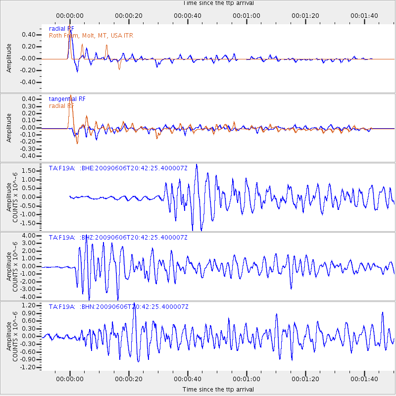
Signal To Noise
| Channel | StoN | STA | LTA |
| TA:F19A: :BHZ:20090606T20:42:25.400007Z | 24.014956 | 1.4240233E-6 | 5.9297353E-8 |
| TA:F19A: :BHN:20090606T20:42:25.400007Z | 1.4959987 | 9.211121E-8 | 6.157172E-8 |
| TA:F19A: :BHE:20090606T20:42:25.400007Z | 5.955385 | 3.9799195E-7 | 6.682892E-8 |
| Arrivals |
| Ps | 6.1 SECOND |
| PpPs | 24 SECOND |
| PsPs/PpSs | 30 SECOND |


