You are here: Home > Network List > TA - USArray Transportable Network (new EarthScope stations) Stations List
> Station F19A Roth Fram, Molt, MT, USA > Earthquake Result Viewer
F19A Roth Fram, Molt, MT, USA - Earthquake Result Viewer
| Earthquake location: |
South Of Panama |
| Earthquake latitude/longitude: |
5.7/-82.8 |
| Earthquake time(UTC): |
2009/03/12 (071) 23:23:34 GMT |
| Earthquake Depth: |
9.0 km |
| Earthquake Magnitude: |
6.1 MB, 5.9 MS, 6.3 MW, 6.2 MW |
| Earthquake Catalog/Contributor: |
WHDF/NEIC |
|
| Network: |
TA USArray Transportable Network (new EarthScope stations) |
| Station: |
F19A Roth Fram, Molt, MT, USA |
| Lat/Lon: |
45.85 N/108.94 W |
| Elevation: |
1243 m |
|
| Distance: |
46.0 deg |
| Az: |
334.624 deg |
| Baz: |
142.396 deg |
| Ray Param: |
0.070913486 |
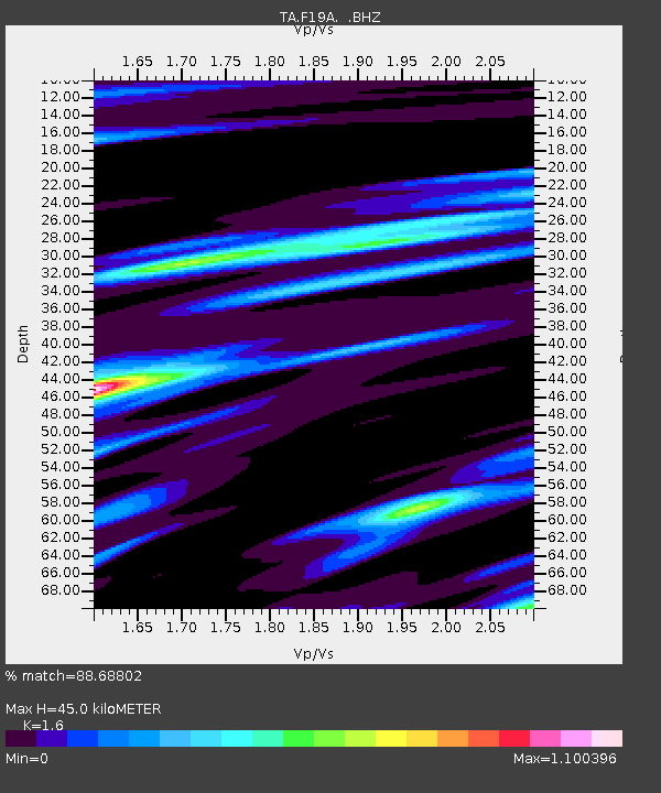
| Estimated Moho Depth: |
45.0 km |
| Estimated Crust Vp/Vs: |
1.60 |
| Assumed Crust Vp: |
6.242 km/s |
| Estimated Crust Vs: |
3.901 km/s |
| Estimated Crust Poisson's Ratio: |
0.18 |
|
| Radial Match: |
88.68802 % |
| Radial Bump: |
375 |
| Transverse Match: |
79.343925 % |
| Transverse Bump: |
400 |
| SOD ConfigId: |
2658 |
| Insert Time: |
2010-03-06 13:09:33.794 +0000 |
| GWidth: |
2.5 |
| Max Bumps: |
400 |
| Tol: |
0.001 |
|

Signal To Noise
| Channel | StoN | STA | LTA |
| TA:F19A: :BHZ:20090312T23:31:27.498986Z | 21.067402 | 2.3003306E-6 | 1.09189095E-7 |
| TA:F19A: :BHN:20090312T23:31:27.498986Z | 6.8264394 | 1.0445901E-6 | 1.5302122E-7 |
| TA:F19A: :BHE:20090312T23:31:27.498986Z | 2.6524205 | 6.244801E-7 | 2.3543781E-7 |
| Arrivals |
| Ps | 4.6 SECOND |
| PpPs | 18 SECOND |
| PsPs/PpSs | 22 SECOND |


