You are here: Home > Network List > TA - USArray Transportable Network (new EarthScope stations) Stations List
> Station C16K Lisburne Hills, AK, USA > Earthquake Result Viewer
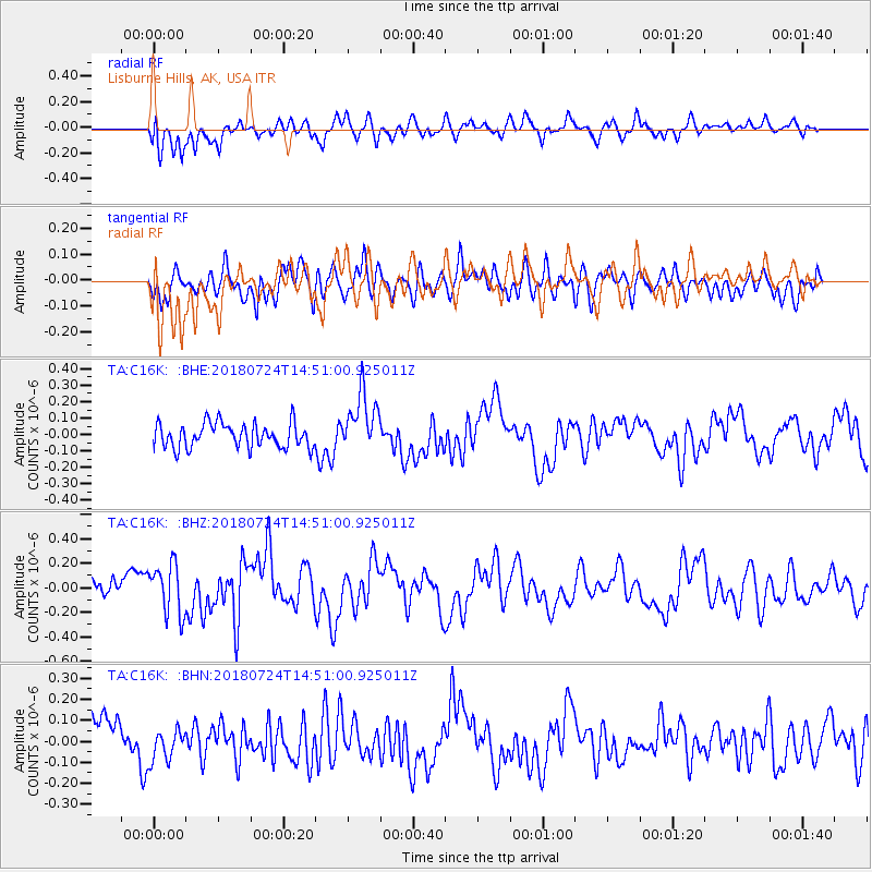
C16K Lisburne Hills, AK, USA - Earthquake Result Viewer
*The percent match for this event was below the threshold and hence no stack was calculated.
| Earthquake location: |
Off Coast Of Northern California |
| Earthquake latitude/longitude: |
41.8/-126.9 |
| Earthquake time(UTC): |
2018/07/24 (205) 14:44:52 GMT |
| Earthquake Depth: |
10 km |
| Earthquake Magnitude: |
5.6 Mw |
| Earthquake Catalog/Contributor: |
NEIC PDE/us |
|
| Network: |
TA USArray Transportable Network (new EarthScope stations) |
| Station: |
C16K Lisburne Hills, AK, USA |
| Lat/Lon: |
68.27 N/165.34 W |
| Elevation: |
102 m |
|
| Distance: |
33.5 deg |
| Az: |
335.151 deg |
| Baz: |
122.456 deg |
| Ray Param: |
$rayparam |
*The percent match for this event was below the threshold and hence was not used in the summary stack. |
|
| Radial Match: |
61.675507 % |
| Radial Bump: |
400 |
| Transverse Match: |
55.152092 % |
| Transverse Bump: |
400 |
| SOD ConfigId: |
13570011 |
| Insert Time: |
2019-04-30 16:10:23.112 +0000 |
| GWidth: |
2.5 |
| Max Bumps: |
400 |
| Tol: |
0.001 |
|
Signal To Noise
| Channel | StoN | STA | LTA |
| TA:C16K: :BHZ:20180724T14:51:00.925011Z | 2.173301 | 2.0385123E-7 | 9.379797E-8 |
| TA:C16K: :BHN:20180724T14:51:00.925011Z | 0.9691882 | 7.8604614E-8 | 8.1103565E-8 |
| TA:C16K: :BHE:20180724T14:51:00.925011Z | 2.4338775 | 1.8048415E-7 | 7.415499E-8 |
| Arrivals |
| Ps | |
| PpPs | |
| PsPs/PpSs | |


