You are here: Home > Network List > NE - New England Seismic Network Stations List
> Station EMMW Machias, ME, USA > Earthquake Result Viewer
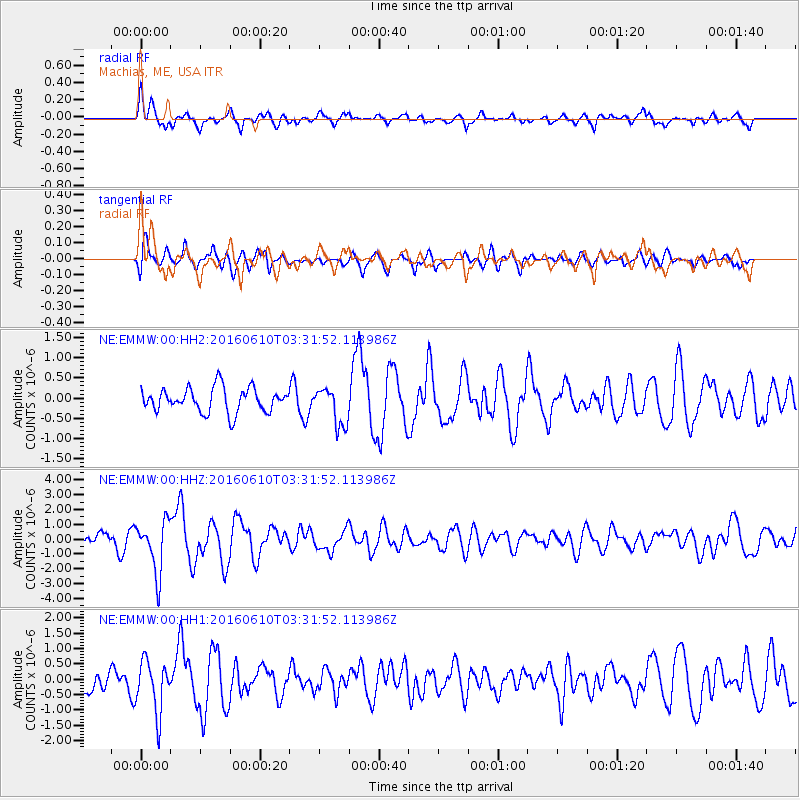
EMMW Machias, ME, USA - Earthquake Result Viewer
*The percent match for this event was below the threshold and hence no stack was calculated.
| Earthquake location: |
Near Coast Of Nicaragua |
| Earthquake latitude/longitude: |
12.8/-87.0 |
| Earthquake time(UTC): |
2016/06/10 (162) 03:25:22 GMT |
| Earthquake Depth: |
10 km |
| Earthquake Magnitude: |
6.1 MWP |
| Earthquake Catalog/Contributor: |
NEIC PDE/NEIC COMCAT |
|
| Network: |
NE New England Seismic Network |
| Station: |
EMMW Machias, ME, USA |
| Lat/Lon: |
44.71 N/67.46 W |
| Elevation: |
35 m |
|
| Distance: |
35.9 deg |
| Az: |
24.027 deg |
| Baz: |
213.843 deg |
| Ray Param: |
$rayparam |
*The percent match for this event was below the threshold and hence was not used in the summary stack. |
|
| Radial Match: |
68.95763 % |
| Radial Bump: |
400 |
| Transverse Match: |
68.17562 % |
| Transverse Bump: |
400 |
| SOD ConfigId: |
1609551 |
| Insert Time: |
2016-06-24 03:27:07.039 +0000 |
| GWidth: |
2.5 |
| Max Bumps: |
400 |
| Tol: |
0.001 |
|
Signal To Noise
| Channel | StoN | STA | LTA |
| NE:EMMW:00:HHZ:20160610T03:31:52.113986Z | 2.9674826 | 1.7372026E-6 | 5.854129E-7 |
| NE:EMMW:00:HH1:20160610T03:31:52.113986Z | 1.8888053 | 8.4193385E-7 | 4.457494E-7 |
| NE:EMMW:00:HH2:20160610T03:31:52.113986Z | 1.572581 | 4.6782245E-7 | 2.9748702E-7 |
| Arrivals |
| Ps | |
| PpPs | |
| PsPs/PpSs | |


