You are here: Home > Network List > CI - Caltech Regional Seismic Network Stations List
> Station PHL Parkhill, California, USA > Earthquake Result Viewer
PHL Parkhill, California, USA - Earthquake Result Viewer
| Earthquake location: |
Tonga Islands |
| Earthquake latitude/longitude: |
-17.2/-173.9 |
| Earthquake time(UTC): |
2000/09/26 (270) 06:17:52 GMT |
| Earthquake Depth: |
56 km |
| Earthquake Magnitude: |
6.1 MB, 6.1 MS, 6.4 MW, 6.1 ME |
| Earthquake Catalog/Contributor: |
WHDF/NEIC |
|
| Network: |
CI Caltech Regional Seismic Network |
| Station: |
PHL Parkhill, California, USA |
| Lat/Lon: |
35.41 N/120.55 W |
| Elevation: |
351 m |
|
| Distance: |
72.8 deg |
| Az: |
43.355 deg |
| Baz: |
233.455 deg |
| Ray Param: |
0.05334096 |
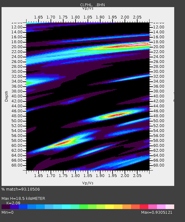
| Estimated Moho Depth: |
18.5 km |
| Estimated Crust Vp/Vs: |
2.09 |
| Assumed Crust Vp: |
6.183 km/s |
| Estimated Crust Vs: |
2.958 km/s |
| Estimated Crust Poisson's Ratio: |
0.35 |
|
| Radial Match: |
93.18506 % |
| Radial Bump: |
400 |
| Transverse Match: |
85.04171 % |
| Transverse Bump: |
400 |
| SOD ConfigId: |
3787 |
| Insert Time: |
2010-02-26 02:06:46.619 +0000 |
| GWidth: |
2.5 |
| Max Bumps: |
400 |
| Tol: |
0.001 |
|
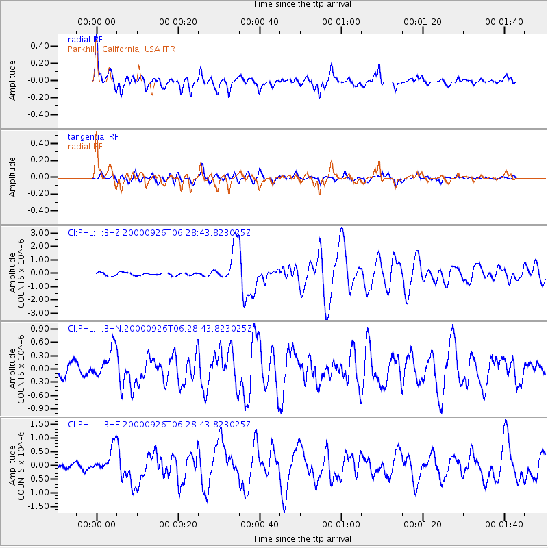
Signal To Noise
| Channel | StoN | STA | LTA |
| CI:PHL: :BHN:20000926T06:28:43.823025Z | 3.0656986 | 3.558339E-7 | 1.1606943E-7 |
| CI:PHL: :BHE:20000926T06:28:43.823025Z | 3.8297913 | 4.8695995E-7 | 1.2715053E-7 |
| CI:PHL: :BHZ:20000926T06:28:43.823025Z | 13.603232 | 1.485418E-6 | 1.0919596E-7 |
| Arrivals |
| Ps | 3.4 SECOND |
| PpPs | 9.0 SECOND |
| PsPs/PpSs | 12 SECOND |


