You are here: Home > Network List > TA - USArray Transportable Network (new EarthScope stations) Stations List
> Station F19A Roth Fram, Molt, MT, USA > Earthquake Result Viewer
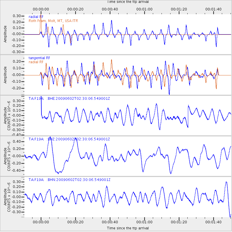
F19A Roth Fram, Molt, MT, USA - Earthquake Result Viewer
*The percent match for this event was below the threshold and hence no stack was calculated.
| Earthquake location: |
Vanuatu Islands |
| Earthquake latitude/longitude: |
-17.8/167.9 |
| Earthquake time(UTC): |
2009/06/02 (153) 02:17:03 GMT |
| Earthquake Depth: |
15 km |
| Earthquake Magnitude: |
5.7 MB, 6.2 MS, 6.3 MW, 6.3 MW |
| Earthquake Catalog/Contributor: |
WHDF/NEIC |
|
| Network: |
TA USArray Transportable Network (new EarthScope stations) |
| Station: |
F19A Roth Fram, Molt, MT, USA |
| Lat/Lon: |
45.85 N/108.94 W |
| Elevation: |
1243 m |
|
| Distance: |
97.9 deg |
| Az: |
44.462 deg |
| Baz: |
252.756 deg |
| Ray Param: |
$rayparam |
*The percent match for this event was below the threshold and hence was not used in the summary stack. |
|
| Radial Match: |
59.271515 % |
| Radial Bump: |
400 |
| Transverse Match: |
67.7405 % |
| Transverse Bump: |
384 |
| SOD ConfigId: |
2648 |
| Insert Time: |
2010-03-06 13:11:00.375 +0000 |
| GWidth: |
2.5 |
| Max Bumps: |
400 |
| Tol: |
0.001 |
|
Signal To Noise
| Channel | StoN | STA | LTA |
| TA:F19A: :BHZ:20090602T02:30:06.549001Z | 2.0844967 | 1.8651882E-7 | 8.9479066E-8 |
| TA:F19A: :BHN:20090602T02:30:06.549001Z | 0.71604156 | 8.435474E-8 | 1.1780703E-7 |
| TA:F19A: :BHE:20090602T02:30:06.549001Z | 0.57190305 | 5.2753958E-8 | 9.224283E-8 |
| Arrivals |
| Ps | |
| PpPs | |
| PsPs/PpSs | |


