You are here: Home > Network List > TA - USArray Transportable Network (new EarthScope stations) Stations List
> Station F19A Roth Fram, Molt, MT, USA > Earthquake Result Viewer
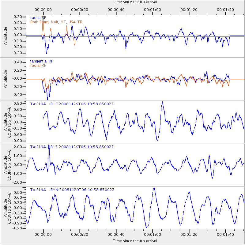
F19A Roth Fram, Molt, MT, USA - Earthquake Result Viewer
*The percent match for this event was below the threshold and hence no stack was calculated.
| Earthquake location: |
Fiji Islands Region |
| Earthquake latitude/longitude: |
-18.7/-177.7 |
| Earthquake time(UTC): |
2008/11/29 (334) 05:59:16 GMT |
| Earthquake Depth: |
386 km |
| Earthquake Magnitude: |
5.7 MB, 6.0 MW, 5.9 MW |
| Earthquake Catalog/Contributor: |
WHDF/NEIC |
|
| Network: |
TA USArray Transportable Network (new EarthScope stations) |
| Station: |
F19A Roth Fram, Molt, MT, USA |
| Lat/Lon: |
45.85 N/108.94 W |
| Elevation: |
1243 m |
|
| Distance: |
89.3 deg |
| Az: |
40.656 deg |
| Baz: |
242.08 deg |
| Ray Param: |
$rayparam |
*The percent match for this event was below the threshold and hence was not used in the summary stack. |
|
| Radial Match: |
60.67469 % |
| Radial Bump: |
400 |
| Transverse Match: |
91.843575 % |
| Transverse Bump: |
306 |
| SOD ConfigId: |
2658 |
| Insert Time: |
2010-03-06 13:11:02.958 +0000 |
| GWidth: |
2.5 |
| Max Bumps: |
400 |
| Tol: |
0.001 |
|
Signal To Noise
| Channel | StoN | STA | LTA |
| TA:F19A: :BHZ:20081129T06:10:58.85002Z | 1.5990868 | 8.191805E-7 | 5.1228017E-7 |
| TA:F19A: :BHN:20081129T06:10:58.85002Z | 0.6201639 | 3.4980457E-7 | 5.640518E-7 |
| TA:F19A: :BHE:20081129T06:10:58.85002Z | 1.4278288 | 4.4588785E-7 | 3.1228382E-7 |
| Arrivals |
| Ps | |
| PpPs | |
| PsPs/PpSs | |


