You are here: Home > Network List > CI - Caltech Regional Seismic Network Stations List
> Station PHL Parkhill, California, USA > Earthquake Result Viewer
PHL Parkhill, California, USA - Earthquake Result Viewer
| Earthquake location: |
Vanuatu Islands |
| Earthquake latitude/longitude: |
-15.7/168.0 |
| Earthquake time(UTC): |
2000/08/09 (222) 00:08:41 GMT |
| Earthquake Depth: |
33 km |
| Earthquake Magnitude: |
6.3 MB, 6.0 MS, 6.4 MW, 6.3 MW |
| Earthquake Catalog/Contributor: |
WHDF/NEIC |
|
| Network: |
CI Caltech Regional Seismic Network |
| Station: |
PHL Parkhill, California, USA |
| Lat/Lon: |
35.41 N/120.55 W |
| Elevation: |
351 m |
|
| Distance: |
84.5 deg |
| Az: |
51.082 deg |
| Baz: |
246.549 deg |
| Ray Param: |
0.045360547 |
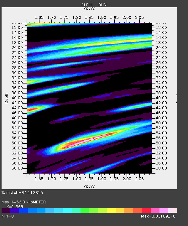
| Estimated Moho Depth: |
56.0 km |
| Estimated Crust Vp/Vs: |
1.87 |
| Assumed Crust Vp: |
6.183 km/s |
| Estimated Crust Vs: |
3.315 km/s |
| Estimated Crust Poisson's Ratio: |
0.30 |
|
| Radial Match: |
84.113815 % |
| Radial Bump: |
400 |
| Transverse Match: |
77.58129 % |
| Transverse Bump: |
400 |
| SOD ConfigId: |
3787 |
| Insert Time: |
2010-02-26 02:06:48.460 +0000 |
| GWidth: |
2.5 |
| Max Bumps: |
400 |
| Tol: |
0.001 |
|
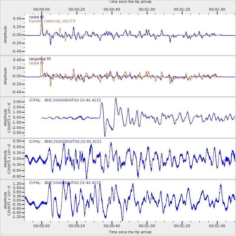
Signal To Noise
| Channel | StoN | STA | LTA |
| CI:PHL: :BHN:20000809T00:20:40.422Z | 2.1012595 | 2.428967E-7 | 1.1559577E-7 |
| CI:PHL: :BHE:20000809T00:20:40.422Z | 2.5750697 | 4.891346E-7 | 1.8995004E-7 |
| CI:PHL: :BHZ:20000809T00:20:40.422Z | 8.474325 | 1.226576E-6 | 1.4474027E-7 |
| Arrivals |
| Ps | 8.0 SECOND |
| PpPs | 25 SECOND |
| PsPs/PpSs | 33 SECOND |


