You are here: Home > Network List > TA - USArray Transportable Network (new EarthScope stations) Stations List
> Station F19A Roth Fram, Molt, MT, USA > Earthquake Result Viewer
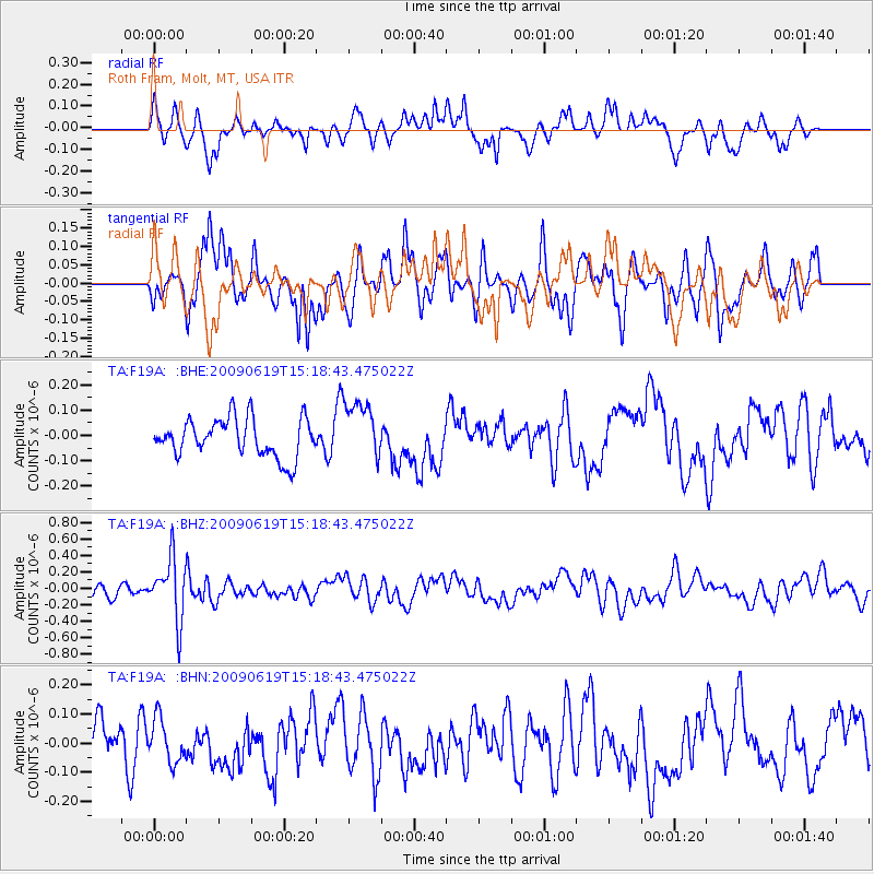
F19A Roth Fram, Molt, MT, USA - Earthquake Result Viewer
*The percent match for this event was below the threshold and hence no stack was calculated.
| Earthquake location: |
Mariana Islands |
| Earthquake latitude/longitude: |
14.1/145.2 |
| Earthquake time(UTC): |
2009/06/19 (170) 15:06:24 GMT |
| Earthquake Depth: |
114 km |
| Earthquake Magnitude: |
5.5 MB, 5.5 MW |
| Earthquake Catalog/Contributor: |
WHDF/NEIC |
|
| Network: |
TA USArray Transportable Network (new EarthScope stations) |
| Station: |
F19A Roth Fram, Molt, MT, USA |
| Lat/Lon: |
45.85 N/108.94 W |
| Elevation: |
1243 m |
|
| Distance: |
90.7 deg |
| Az: |
42.247 deg |
| Baz: |
291.019 deg |
| Ray Param: |
$rayparam |
*The percent match for this event was below the threshold and hence was not used in the summary stack. |
|
| Radial Match: |
54.44028 % |
| Radial Bump: |
400 |
| Transverse Match: |
59.425537 % |
| Transverse Bump: |
348 |
| SOD ConfigId: |
2648 |
| Insert Time: |
2010-03-06 13:11:18.310 +0000 |
| GWidth: |
2.5 |
| Max Bumps: |
400 |
| Tol: |
0.001 |
|
Signal To Noise
| Channel | StoN | STA | LTA |
| TA:F19A: :BHZ:20090619T15:18:43.475022Z | 5.319672 | 3.681176E-7 | 6.91993E-8 |
| TA:F19A: :BHN:20090619T15:18:43.475022Z | 1.3124658 | 7.411197E-8 | 5.646774E-8 |
| TA:F19A: :BHE:20090619T15:18:43.475022Z | 1.5367739 | 1.1624849E-7 | 7.56445E-8 |
| Arrivals |
| Ps | |
| PpPs | |
| PsPs/PpSs | |


