You are here: Home > Network List > TA - USArray Transportable Network (new EarthScope stations) Stations List
> Station F19A Roth Fram, Molt, MT, USA > Earthquake Result Viewer
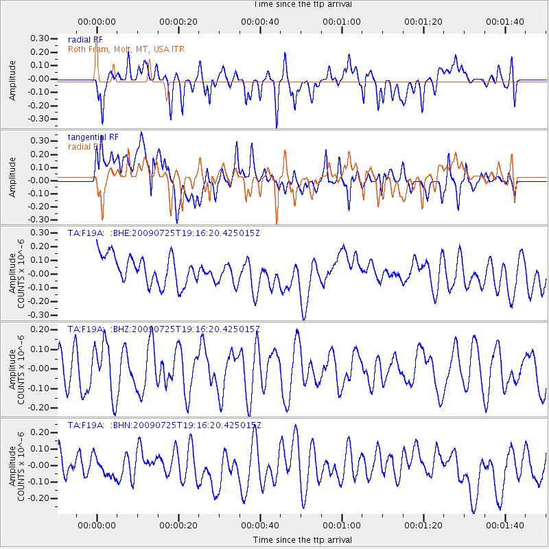
F19A Roth Fram, Molt, MT, USA - Earthquake Result Viewer
*The percent match for this event was below the threshold and hence no stack was calculated.
| Earthquake location: |
Kermadec Islands, New Zealand |
| Earthquake latitude/longitude: |
-29.8/-177.7 |
| Earthquake time(UTC): |
2009/07/25 (206) 19:03:20 GMT |
| Earthquake Depth: |
35 km |
| Earthquake Magnitude: |
5.5 MB, 5.2 MS, 5.6 MW, 5.6 MW |
| Earthquake Catalog/Contributor: |
WHDF/NEIC |
|
| Network: |
TA USArray Transportable Network (new EarthScope stations) |
| Station: |
F19A Roth Fram, Molt, MT, USA |
| Lat/Lon: |
45.85 N/108.94 W |
| Elevation: |
1243 m |
|
| Distance: |
97.7 deg |
| Az: |
41.089 deg |
| Baz: |
234.844 deg |
| Ray Param: |
$rayparam |
*The percent match for this event was below the threshold and hence was not used in the summary stack. |
|
| Radial Match: |
50.938267 % |
| Radial Bump: |
400 |
| Transverse Match: |
57.78672 % |
| Transverse Bump: |
400 |
| SOD ConfigId: |
2648 |
| Insert Time: |
2010-03-06 13:11:41.583 +0000 |
| GWidth: |
2.5 |
| Max Bumps: |
400 |
| Tol: |
0.001 |
|
Signal To Noise
| Channel | StoN | STA | LTA |
| TA:F19A: :BHZ:20090725T19:16:20.425015Z | 1.6409625 | 1.3876445E-7 | 8.456284E-8 |
| TA:F19A: :BHN:20090725T19:16:20.425015Z | 0.728407 | 5.7097395E-8 | 7.8386655E-8 |
| TA:F19A: :BHE:20090725T19:16:20.425015Z | 0.79837346 | 8.2878884E-8 | 1.0380967E-7 |
| Arrivals |
| Ps | |
| PpPs | |
| PsPs/PpSs | |


