You are here: Home > Network List > TA - USArray Transportable Network (new EarthScope stations) Stations List
> Station F19A Roth Fram, Molt, MT, USA > Earthquake Result Viewer
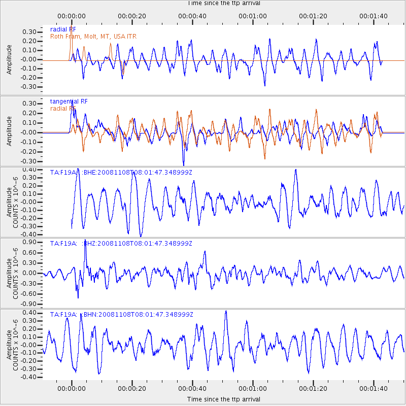
F19A Roth Fram, Molt, MT, USA - Earthquake Result Viewer
*The percent match for this event was below the threshold and hence no stack was calculated.
| Earthquake location: |
Tonga Islands |
| Earthquake latitude/longitude: |
-15.2/-174.2 |
| Earthquake time(UTC): |
2008/11/08 (313) 07:49:59 GMT |
| Earthquake Depth: |
121 km |
| Earthquake Magnitude: |
6.0 MW, 5.4 MB, 6.0 MW |
| Earthquake Catalog/Contributor: |
WHDF/NEIC |
|
| Network: |
TA USArray Transportable Network (new EarthScope stations) |
| Station: |
F19A Roth Fram, Molt, MT, USA |
| Lat/Lon: |
45.85 N/108.94 W |
| Elevation: |
1243 m |
|
| Distance: |
84.5 deg |
| Az: |
39.628 deg |
| Baz: |
241.76 deg |
| Ray Param: |
$rayparam |
*The percent match for this event was below the threshold and hence was not used in the summary stack. |
|
| Radial Match: |
63.692165 % |
| Radial Bump: |
400 |
| Transverse Match: |
51.50948 % |
| Transverse Bump: |
368 |
| SOD ConfigId: |
2658 |
| Insert Time: |
2010-03-06 13:11:44.129 +0000 |
| GWidth: |
2.5 |
| Max Bumps: |
400 |
| Tol: |
0.001 |
|
Signal To Noise
| Channel | StoN | STA | LTA |
| TA:F19A: :BHZ:20081108T08:01:47.348999Z | 4.3754277 | 3.6289302E-7 | 8.293887E-8 |
| TA:F19A: :BHN:20081108T08:01:47.348999Z | 1.4170715 | 2.2284142E-7 | 1.5725489E-7 |
| TA:F19A: :BHE:20081108T08:01:47.348999Z | 0.64454323 | 1.3124546E-7 | 2.0362552E-7 |
| Arrivals |
| Ps | |
| PpPs | |
| PsPs/PpSs | |


