You are here: Home > Network List > AK - Alaska Regional Network Stations List
> Station MDM Murphy Dome > Earthquake Result Viewer
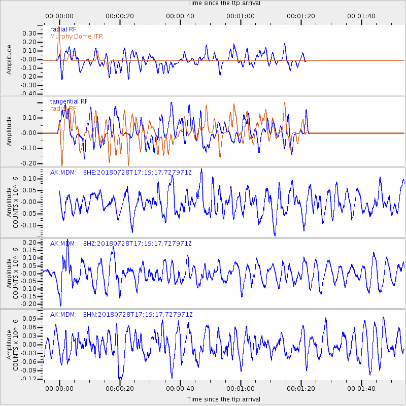
MDM Murphy Dome - Earthquake Result Viewer
*The percent match for this event was below the threshold and hence no stack was calculated.
| Earthquake location: |
Flores Sea |
| Earthquake latitude/longitude: |
-7.1/122.7 |
| Earthquake time(UTC): |
2018/07/28 (209) 17:07:23 GMT |
| Earthquake Depth: |
577 km |
| Earthquake Magnitude: |
6.0 Mww |
| Earthquake Catalog/Contributor: |
NEIC PDE/us |
|
| Network: |
AK Alaska Regional Network |
| Station: |
MDM Murphy Dome |
| Lat/Lon: |
64.96 N/148.23 W |
| Elevation: |
634 m |
|
| Distance: |
96.0 deg |
| Az: |
25.333 deg |
| Baz: |
266.095 deg |
| Ray Param: |
$rayparam |
*The percent match for this event was below the threshold and hence was not used in the summary stack. |
|
| Radial Match: |
48.748997 % |
| Radial Bump: |
400 |
| Transverse Match: |
45.568916 % |
| Transverse Bump: |
400 |
| SOD ConfigId: |
13570011 |
| Insert Time: |
2019-04-30 16:30:35.660 +0000 |
| GWidth: |
2.5 |
| Max Bumps: |
400 |
| Tol: |
0.001 |
|
Signal To Noise
| Channel | StoN | STA | LTA |
| AK:MDM: :BHZ:20180728T17:19:17.727971Z | 2.7711 | 1.07652376E-7 | 3.884825E-8 |
| AK:MDM: :BHN:20180728T17:19:17.727971Z | 0.86735785 | 4.0260115E-8 | 4.641696E-8 |
| AK:MDM: :BHE:20180728T17:19:17.727971Z | 0.92906046 | 3.572937E-8 | 3.8457532E-8 |
| Arrivals |
| Ps | |
| PpPs | |
| PsPs/PpSs | |


