You are here: Home > Network List > TA - USArray Transportable Network (new EarthScope stations) Stations List
> Station F19A Roth Fram, Molt, MT, USA > Earthquake Result Viewer
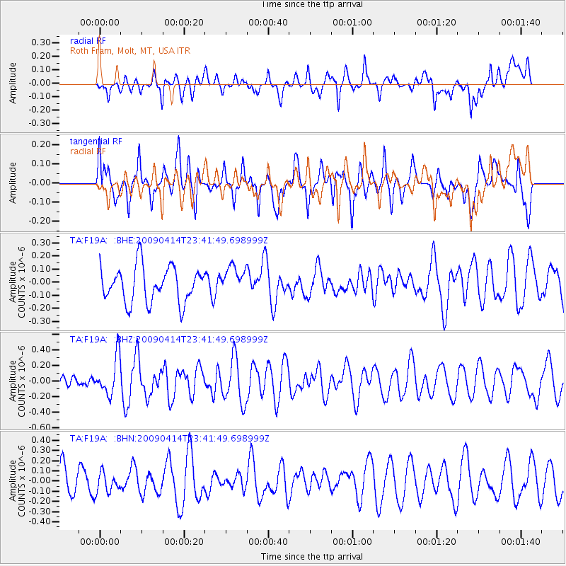
F19A Roth Fram, Molt, MT, USA - Earthquake Result Viewer
*The percent match for this event was below the threshold and hence no stack was calculated.
| Earthquake location: |
Fiji Islands Region |
| Earthquake latitude/longitude: |
-16.3/-177.7 |
| Earthquake time(UTC): |
2009/04/14 (104) 23:29:33 GMT |
| Earthquake Depth: |
10 km |
| Earthquake Magnitude: |
5.5 MS, 5.4 MB, 5.9 MW, 5.9 MW |
| Earthquake Catalog/Contributor: |
WHDF/NEIC |
|
| Network: |
TA USArray Transportable Network (new EarthScope stations) |
| Station: |
F19A Roth Fram, Molt, MT, USA |
| Lat/Lon: |
45.85 N/108.94 W |
| Elevation: |
1243 m |
|
| Distance: |
87.5 deg |
| Az: |
40.704 deg |
| Baz: |
243.644 deg |
| Ray Param: |
$rayparam |
*The percent match for this event was below the threshold and hence was not used in the summary stack. |
|
| Radial Match: |
57.50771 % |
| Radial Bump: |
400 |
| Transverse Match: |
54.249084 % |
| Transverse Bump: |
400 |
| SOD ConfigId: |
2658 |
| Insert Time: |
2010-03-06 13:12:11.547 +0000 |
| GWidth: |
2.5 |
| Max Bumps: |
400 |
| Tol: |
0.001 |
|
Signal To Noise
| Channel | StoN | STA | LTA |
| TA:F19A: :BHZ:20090414T23:41:49.698999Z | 2.6629705 | 2.505388E-7 | 9.408245E-8 |
| TA:F19A: :BHN:20090414T23:41:49.698999Z | 0.4837857 | 9.49887E-8 | 1.9634459E-7 |
| TA:F19A: :BHE:20090414T23:41:49.698999Z | 0.8297687 | 1.12028545E-7 | 1.3501177E-7 |
| Arrivals |
| Ps | |
| PpPs | |
| PsPs/PpSs | |


