You are here: Home > Network List > AV - Alaska Volcano Observatory Stations List
> Station SPU Mount Spurr, Mount Spurr, Alaska > Earthquake Result Viewer
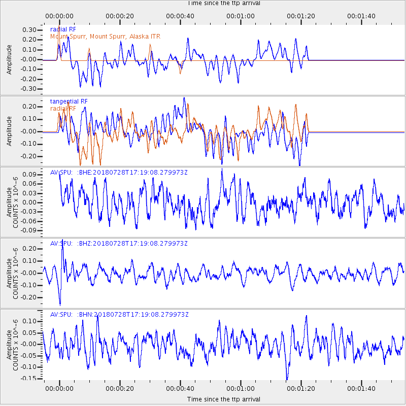
SPU Mount Spurr, Mount Spurr, Alaska - Earthquake Result Viewer
*The percent match for this event was below the threshold and hence no stack was calculated.
| Earthquake location: |
Flores Sea |
| Earthquake latitude/longitude: |
-7.1/122.7 |
| Earthquake time(UTC): |
2018/07/28 (209) 17:07:23 GMT |
| Earthquake Depth: |
577 km |
| Earthquake Magnitude: |
6.0 Mww |
| Earthquake Catalog/Contributor: |
NEIC PDE/us |
|
| Network: |
AV Alaska Volcano Observatory |
| Station: |
SPU Mount Spurr, Mount Spurr, Alaska |
| Lat/Lon: |
61.18 N/152.06 W |
| Elevation: |
800 m |
|
| Distance: |
93.9 deg |
| Az: |
28.942 deg |
| Baz: |
262.375 deg |
| Ray Param: |
$rayparam |
*The percent match for this event was below the threshold and hence was not used in the summary stack. |
|
| Radial Match: |
55.814175 % |
| Radial Bump: |
400 |
| Transverse Match: |
51.46445 % |
| Transverse Bump: |
400 |
| SOD ConfigId: |
13570011 |
| Insert Time: |
2019-04-30 16:31:09.232 +0000 |
| GWidth: |
2.5 |
| Max Bumps: |
400 |
| Tol: |
0.001 |
|
Signal To Noise
| Channel | StoN | STA | LTA |
| AV:SPU: :BHZ:20180728T17:19:08.279973Z | 3.3064735 | 1.1771058E-7 | 3.5600035E-8 |
| AV:SPU: :BHN:20180728T17:19:08.279973Z | 0.72827834 | 3.403944E-8 | 4.6739604E-8 |
| AV:SPU: :BHE:20180728T17:19:08.279973Z | 1.0225044 | 3.9252775E-8 | 3.838886E-8 |
| Arrivals |
| Ps | |
| PpPs | |
| PsPs/PpSs | |


