You are here: Home > Network List > TA - USArray Transportable Network (new EarthScope stations) Stations List
> Station W24A Lazy 6 Ranch, Villanueva, NM, USA > Earthquake Result Viewer
W24A Lazy 6 Ranch, Villanueva, NM, USA - Earthquake Result Viewer
| Earthquake location: |
Easter Island Region |
| Earthquake latitude/longitude: |
-28.5/-112.8 |
| Earthquake time(UTC): |
2008/08/19 (232) 10:58:00 GMT |
| Earthquake Depth: |
9.0 km |
| Earthquake Magnitude: |
5.5 MB, 5.3 MS, 5.7 MW, 5.7 MW |
| Earthquake Catalog/Contributor: |
WHDF/NEIC |
|
| Network: |
TA USArray Transportable Network (new EarthScope stations) |
| Station: |
W24A Lazy 6 Ranch, Villanueva, NM, USA |
| Lat/Lon: |
35.21 N/105.41 W |
| Elevation: |
1902 m |
|
| Distance: |
63.8 deg |
| Az: |
6.782 deg |
| Baz: |
187.289 deg |
| Ray Param: |
0.059342764 |
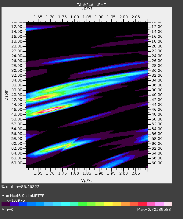
| Estimated Moho Depth: |
46.0 km |
| Estimated Crust Vp/Vs: |
1.70 |
| Assumed Crust Vp: |
6.419 km/s |
| Estimated Crust Vs: |
3.782 km/s |
| Estimated Crust Poisson's Ratio: |
0.23 |
|
| Radial Match: |
86.46322 % |
| Radial Bump: |
400 |
| Transverse Match: |
52.62046 % |
| Transverse Bump: |
400 |
| SOD ConfigId: |
2504 |
| Insert Time: |
2010-03-06 13:12:44.603 +0000 |
| GWidth: |
2.5 |
| Max Bumps: |
400 |
| Tol: |
0.001 |
|

Signal To Noise
| Channel | StoN | STA | LTA |
| TA:W24A: :BHZ:20080819T11:08:01.423999Z | 13.328406 | 6.336185E-7 | 4.7538958E-8 |
| TA:W24A: :BHN:20080819T11:08:01.423999Z | 6.8108597 | 3.083124E-7 | 4.5267765E-8 |
| TA:W24A: :BHE:20080819T11:08:01.423999Z | 1.3920661 | 1.6211267E-7 | 1.1645472E-7 |
| Arrivals |
| Ps | 5.2 SECOND |
| PpPs | 18 SECOND |
| PsPs/PpSs | 24 SECOND |


