You are here: Home > Network List > TA - USArray Transportable Network (new EarthScope stations) Stations List
> Station W24A Lazy 6 Ranch, Villanueva, NM, USA > Earthquake Result Viewer
W24A Lazy 6 Ranch, Villanueva, NM, USA - Earthquake Result Viewer
| Earthquake location: |
Tonga Islands |
| Earthquake latitude/longitude: |
-21.9/-173.8 |
| Earthquake time(UTC): |
2008/10/19 (293) 05:10:33 GMT |
| Earthquake Depth: |
29 km |
| Earthquake Magnitude: |
6.8 MB, 7.0 MS, 6.9 MW, 6.9 MW |
| Earthquake Catalog/Contributor: |
WHDF/NEIC |
|
| Network: |
TA USArray Transportable Network (new EarthScope stations) |
| Station: |
W24A Lazy 6 Ranch, Villanueva, NM, USA |
| Lat/Lon: |
35.21 N/105.41 W |
| Elevation: |
1902 m |
|
| Distance: |
86.1 deg |
| Az: |
49.742 deg |
| Baz: |
239.967 deg |
| Ray Param: |
0.044230804 |
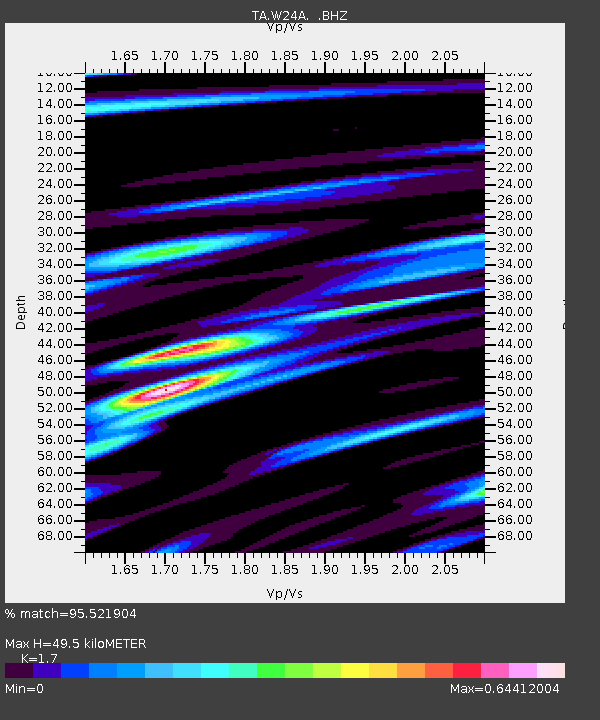
| Estimated Moho Depth: |
49.5 km |
| Estimated Crust Vp/Vs: |
1.70 |
| Assumed Crust Vp: |
6.419 km/s |
| Estimated Crust Vs: |
3.776 km/s |
| Estimated Crust Poisson's Ratio: |
0.24 |
|
| Radial Match: |
95.521904 % |
| Radial Bump: |
336 |
| Transverse Match: |
90.52345 % |
| Transverse Bump: |
400 |
| SOD ConfigId: |
2556 |
| Insert Time: |
2010-03-06 13:12:54.058 +0000 |
| GWidth: |
2.5 |
| Max Bumps: |
400 |
| Tol: |
0.001 |
|

Signal To Noise
| Channel | StoN | STA | LTA |
| TA:W24A: :BHZ:20081019T05:22:40.875027Z | 57.40558 | 6.720022E-6 | 1.17062186E-7 |
| TA:W24A: :BHN:20081019T05:22:40.875027Z | 8.505944 | 1.3226171E-6 | 1.5549327E-7 |
| TA:W24A: :BHE:20081019T05:22:40.875027Z | 12.676778 | 2.0822642E-6 | 1.6425815E-7 |
| Arrivals |
| Ps | 5.5 SECOND |
| PpPs | 20 SECOND |
| PsPs/PpSs | 26 SECOND |


