You are here: Home > Network List > 2H - Interim Broadband Monitoring of the Mount Erebus Volcano Stations List
> Station CONZ Mt Erebus site CONZ > Earthquake Result Viewer
CONZ Mt Erebus site CONZ - Earthquake Result Viewer
| Earthquake location: |
Sumbawa Region, Indonesia |
| Earthquake latitude/longitude: |
-8.3/116.5 |
| Earthquake time(UTC): |
2018/07/28 (209) 22:47:37 GMT |
| Earthquake Depth: |
6.4 km |
| Earthquake Magnitude: |
6.4 Mww |
| Earthquake Catalog/Contributor: |
NEIC PDE/us |
|
| Network: |
2H Interim Broadband Monitoring of the Mount Erebus Volcano |
| Station: |
CONZ Mt Erebus site CONZ |
| Lat/Lon: |
77.53 S/167.08 E |
| Elevation: |
3433 m |
|
| Distance: |
74.0 deg |
| Az: |
169.941 deg |
| Baz: |
307.286 deg |
| Ray Param: |
0.0526517 |
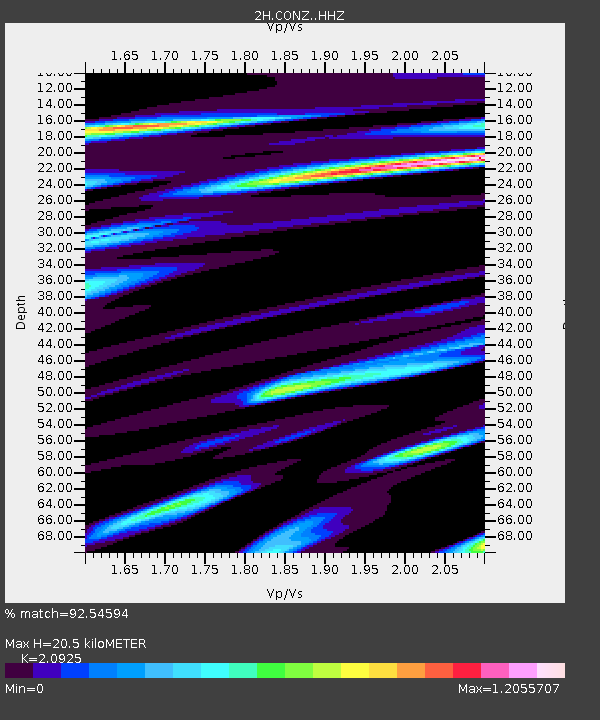
| Estimated Moho Depth: |
20.5 km |
| Estimated Crust Vp/Vs: |
2.09 |
| Assumed Crust Vp: |
6.183 km/s |
| Estimated Crust Vs: |
2.955 km/s |
| Estimated Crust Poisson's Ratio: |
0.35 |
|
| Radial Match: |
92.54594 % |
| Radial Bump: |
400 |
| Transverse Match: |
86.1238 % |
| Transverse Bump: |
400 |
| SOD ConfigId: |
13570011 |
| Insert Time: |
2019-04-30 16:34:54.487 +0000 |
| GWidth: |
2.5 |
| Max Bumps: |
400 |
| Tol: |
0.001 |
|

Signal To Noise
| Channel | StoN | STA | LTA |
| 2H:CONZ: :HHZ:20180728T22:58:42.464011Z | 13.961914 | 3.007885E-6 | 2.1543501E-7 |
| 2H:CONZ: :HH1:20180728T22:58:42.464011Z | 1.984355 | 6.8275455E-7 | 3.4406875E-7 |
| 2H:CONZ: :HH2:20180728T22:58:42.464011Z | 5.630018 | 1.528439E-6 | 2.714803E-7 |
| Arrivals |
| Ps | 3.7 SECOND |
| PpPs | 10.0 SECOND |
| PsPs/PpSs | 14 SECOND |


