You are here: Home > Network List > AV - Alaska Volcano Observatory Stations List
> Station MAPS Pakushin Southeast, Makushin Volcano, Alaska > Earthquake Result Viewer
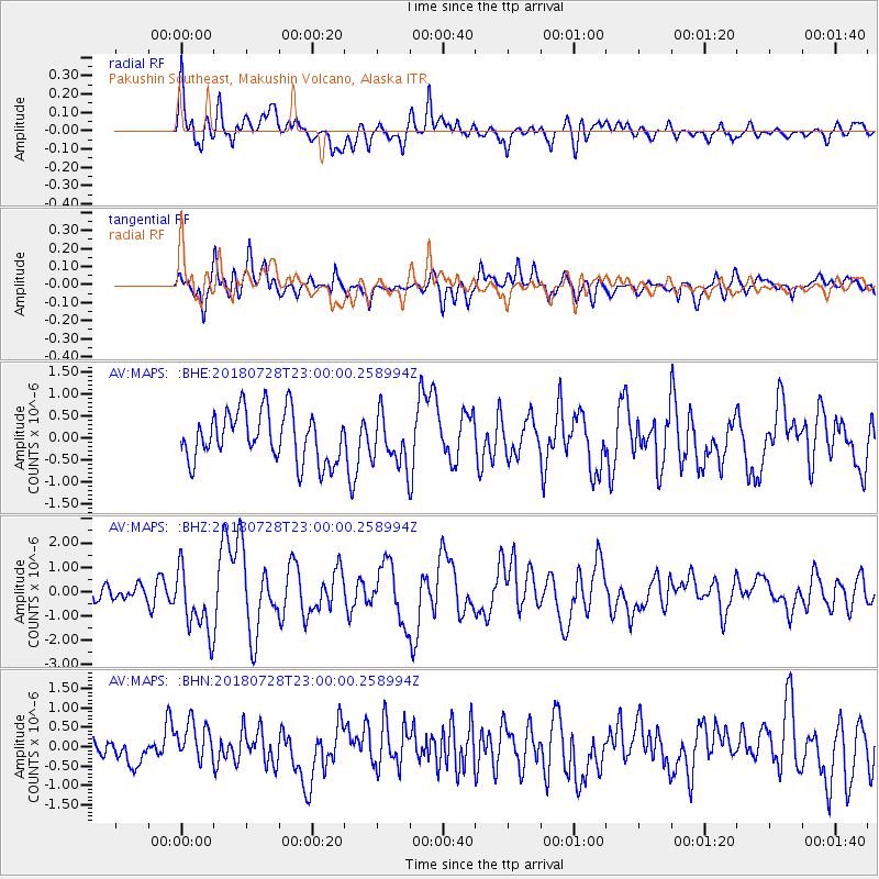
MAPS Pakushin Southeast, Makushin Volcano, Alaska - Earthquake Result Viewer
*The percent match for this event was below the threshold and hence no stack was calculated.
| Earthquake location: |
Sumbawa Region, Indonesia |
| Earthquake latitude/longitude: |
-8.3/116.5 |
| Earthquake time(UTC): |
2018/07/28 (209) 22:47:37 GMT |
| Earthquake Depth: |
6.4 km |
| Earthquake Magnitude: |
6.4 Mww |
| Earthquake Catalog/Contributor: |
NEIC PDE/us |
|
| Network: |
AV Alaska Volcano Observatory |
| Station: |
MAPS Pakushin Southeast, Makushin Volcano, Alaska |
| Lat/Lon: |
53.81 N/166.94 W |
| Elevation: |
333 m |
|
| Distance: |
88.8 deg |
| Az: |
35.238 deg |
| Baz: |
254.339 deg |
| Ray Param: |
$rayparam |
*The percent match for this event was below the threshold and hence was not used in the summary stack. |
|
| Radial Match: |
67.112495 % |
| Radial Bump: |
400 |
| Transverse Match: |
67.57781 % |
| Transverse Bump: |
400 |
| SOD ConfigId: |
13570011 |
| Insert Time: |
2019-04-30 16:35:27.748 +0000 |
| GWidth: |
2.5 |
| Max Bumps: |
400 |
| Tol: |
0.001 |
|
Signal To Noise
| Channel | StoN | STA | LTA |
| AV:MAPS: :BHZ:20180728T23:00:00.258994Z | 4.5623536 | 1.4033459E-6 | 3.0759256E-7 |
| AV:MAPS: :BHN:20180728T23:00:00.258994Z | 1.6621541 | 5.208957E-7 | 3.1338593E-7 |
| AV:MAPS: :BHE:20180728T23:00:00.258994Z | 1.1227318 | 6.274211E-7 | 5.5883436E-7 |
| Arrivals |
| Ps | |
| PpPs | |
| PsPs/PpSs | |


