You are here: Home > Network List > CB - China National Seismic Network Stations List
> Station GOM Geermu,Qinghai Province > Earthquake Result Viewer
GOM Geermu,Qinghai Province - Earthquake Result Viewer
| Earthquake location: |
Sumbawa Region, Indonesia |
| Earthquake latitude/longitude: |
-8.3/116.5 |
| Earthquake time(UTC): |
2018/07/28 (209) 22:47:37 GMT |
| Earthquake Depth: |
6.4 km |
| Earthquake Magnitude: |
6.4 Mww |
| Earthquake Catalog/Contributor: |
NEIC PDE/us |
|
| Network: |
CB China National Seismic Network |
| Station: |
GOM Geermu,Qinghai Province |
| Lat/Lon: |
36.20 N/94.81 E |
| Elevation: |
3121 m |
|
| Distance: |
48.7 deg |
| Az: |
336.57 deg |
| Baz: |
150.886 deg |
| Ray Param: |
0.069190584 |
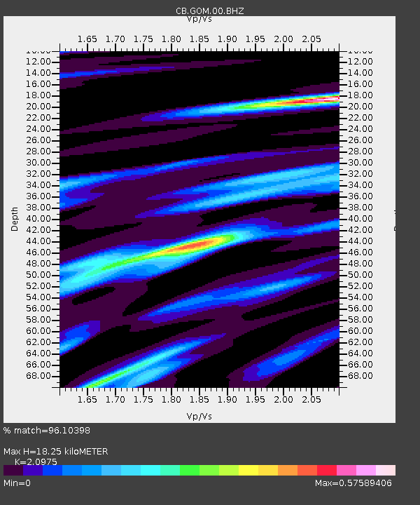
| Estimated Moho Depth: |
18.25 km |
| Estimated Crust Vp/Vs: |
2.10 |
| Assumed Crust Vp: |
6.385 km/s |
| Estimated Crust Vs: |
3.044 km/s |
| Estimated Crust Poisson's Ratio: |
0.35 |
|
| Radial Match: |
96.10398 % |
| Radial Bump: |
286 |
| Transverse Match: |
91.25544 % |
| Transverse Bump: |
400 |
| SOD ConfigId: |
13570011 |
| Insert Time: |
2019-04-30 16:35:44.855 +0000 |
| GWidth: |
2.5 |
| Max Bumps: |
400 |
| Tol: |
0.001 |
|

Signal To Noise
| Channel | StoN | STA | LTA |
| CB:GOM:00:BHZ:20180728T22:55:51.450004Z | 14.764807 | 1.3623873E-6 | 9.227261E-8 |
| CB:GOM:00:BHN:20180728T22:55:51.450004Z | 10.114675 | 4.2809063E-7 | 4.232372E-8 |
| CB:GOM:00:BHE:20180728T22:55:51.450004Z | 5.0047636 | 1.7819109E-7 | 3.5604295E-8 |
| Arrivals |
| Ps | 3.3 SECOND |
| PpPs | 8.4 SECOND |
| PsPs/PpSs | 12 SECOND |


