You are here: Home > Network List > TA - USArray Transportable Network (new EarthScope stations) Stations List
> Station W24A Lazy 6 Ranch, Villanueva, NM, USA > Earthquake Result Viewer
W24A Lazy 6 Ranch, Villanueva, NM, USA - Earthquake Result Viewer
| Earthquake location: |
Near East Coast Of Honshu, Japan |
| Earthquake latitude/longitude: |
35.5/140.9 |
| Earthquake time(UTC): |
2009/06/06 (157) 05:52:43 GMT |
| Earthquake Depth: |
34 km |
| Earthquake Magnitude: |
5.8 MB, 5.4 MS, 5.8 MW, 5.7 MW |
| Earthquake Catalog/Contributor: |
WHDF/NEIC |
|
| Network: |
TA USArray Transportable Network (new EarthScope stations) |
| Station: |
W24A Lazy 6 Ranch, Villanueva, NM, USA |
| Lat/Lon: |
35.21 N/105.41 W |
| Elevation: |
1902 m |
|
| Distance: |
86.4 deg |
| Az: |
48.714 deg |
| Baz: |
311.503 deg |
| Ray Param: |
0.044056367 |
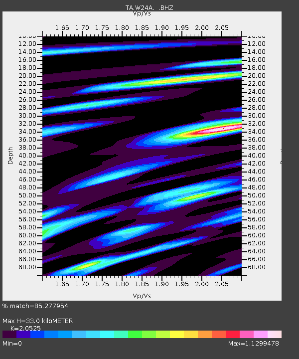
| Estimated Moho Depth: |
33.0 km |
| Estimated Crust Vp/Vs: |
2.05 |
| Assumed Crust Vp: |
6.419 km/s |
| Estimated Crust Vs: |
3.128 km/s |
| Estimated Crust Poisson's Ratio: |
0.34 |
|
| Radial Match: |
85.277954 % |
| Radial Bump: |
400 |
| Transverse Match: |
74.79122 % |
| Transverse Bump: |
400 |
| SOD ConfigId: |
2648 |
| Insert Time: |
2010-03-06 13:13:39.223 +0000 |
| GWidth: |
2.5 |
| Max Bumps: |
400 |
| Tol: |
0.001 |
|

Signal To Noise
| Channel | StoN | STA | LTA |
| TA:W24A: :BHZ:20090606T06:04:50.825024Z | 8.560072 | 7.5438925E-7 | 8.812885E-8 |
| TA:W24A: :BHN:20090606T06:04:50.825024Z | 2.4781065 | 1.7438627E-7 | 7.0370774E-8 |
| TA:W24A: :BHE:20090606T06:04:50.825024Z | 2.8743045 | 2.5027728E-7 | 8.7074035E-8 |
| Arrivals |
| Ps | 5.5 SECOND |
| PpPs | 15 SECOND |
| PsPs/PpSs | 21 SECOND |


