You are here: Home > Network List > KR - Kyrgyz Digital Network Stations List
> Station PRZ Karakol, Kyrgyzstan > Earthquake Result Viewer
PRZ Karakol, Kyrgyzstan - Earthquake Result Viewer
| Earthquake location: |
Sumbawa Region, Indonesia |
| Earthquake latitude/longitude: |
-8.3/116.5 |
| Earthquake time(UTC): |
2018/07/28 (209) 22:47:37 GMT |
| Earthquake Depth: |
6.4 km |
| Earthquake Magnitude: |
6.4 Mww |
| Earthquake Catalog/Contributor: |
NEIC PDE/us |
|
| Network: |
KR Kyrgyz Digital Network |
| Station: |
PRZ Karakol, Kyrgyzstan |
| Lat/Lon: |
42.47 N/78.40 E |
| Elevation: |
1835 m |
|
| Distance: |
61.3 deg |
| Az: |
328.647 deg |
| Baz: |
135.889 deg |
| Ray Param: |
0.060966294 |
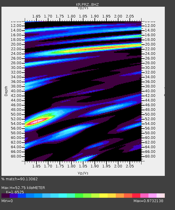
| Estimated Moho Depth: |
52.75 km |
| Estimated Crust Vp/Vs: |
1.65 |
| Assumed Crust Vp: |
6.306 km/s |
| Estimated Crust Vs: |
3.816 km/s |
| Estimated Crust Poisson's Ratio: |
0.21 |
|
| Radial Match: |
90.13062 % |
| Radial Bump: |
400 |
| Transverse Match: |
88.29408 % |
| Transverse Bump: |
400 |
| SOD ConfigId: |
13570011 |
| Insert Time: |
2019-04-30 16:36:47.641 +0000 |
| GWidth: |
2.5 |
| Max Bumps: |
400 |
| Tol: |
0.001 |
|

Signal To Noise
| Channel | StoN | STA | LTA |
| KR:PRZ: :BHZ:20180728T22:57:22.51998Z | 20.681204 | 1.25443E-6 | 6.065556E-8 |
| KR:PRZ: :BHN:20180728T22:57:22.51998Z | 4.0250244 | 2.3582649E-7 | 5.8590075E-8 |
| KR:PRZ: :BHE:20180728T22:57:22.51998Z | 4.743161 | 3.293572E-7 | 6.943833E-8 |
| Arrivals |
| Ps | 5.7 SECOND |
| PpPs | 21 SECOND |
| PsPs/PpSs | 27 SECOND |


