You are here: Home > Network List > S - Seismographs in Schools Projects Stations List
> Station AUBRN Burnie High School, Burnie, TAS > Earthquake Result Viewer
AUBRN Burnie High School, Burnie, TAS - Earthquake Result Viewer
| Earthquake location: |
Sumbawa Region, Indonesia |
| Earthquake latitude/longitude: |
-8.3/116.5 |
| Earthquake time(UTC): |
2018/07/28 (209) 22:47:37 GMT |
| Earthquake Depth: |
6.4 km |
| Earthquake Magnitude: |
6.4 Mww |
| Earthquake Catalog/Contributor: |
NEIC PDE/us |
|
| Network: |
S Seismographs in Schools Projects |
| Station: |
AUBRN Burnie High School, Burnie, TAS |
| Lat/Lon: |
41.04 S/145.87 E |
| Elevation: |
10 m |
|
| Distance: |
41.8 deg |
| Az: |
146.144 deg |
| Baz: |
313.203 deg |
| Ray Param: |
0.073595144 |
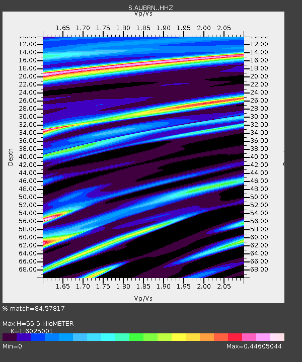
| Estimated Moho Depth: |
55.5 km |
| Estimated Crust Vp/Vs: |
1.60 |
| Assumed Crust Vp: |
6.477 km/s |
| Estimated Crust Vs: |
4.042 km/s |
| Estimated Crust Poisson's Ratio: |
0.18 |
|
| Radial Match: |
84.57817 % |
| Radial Bump: |
400 |
| Transverse Match: |
69.625374 % |
| Transverse Bump: |
400 |
| SOD ConfigId: |
13570011 |
| Insert Time: |
2019-04-30 16:37:14.393 +0000 |
| GWidth: |
2.5 |
| Max Bumps: |
400 |
| Tol: |
0.001 |
|

Signal To Noise
| Channel | StoN | STA | LTA |
| S:AUBRN: :HHZ:20180728T22:54:56.749991Z | 4.1240315 | 3.14336E-6 | 7.622056E-7 |
| S:AUBRN: :HHN:20180728T22:54:56.749991Z | 4.1594853 | 2.9695268E-6 | 7.1391685E-7 |
| S:AUBRN: :HHE:20180728T22:54:56.749991Z | 2.3525984 | 1.4243399E-6 | 6.054326E-7 |
| Arrivals |
| Ps | 5.6 SECOND |
| PpPs | 21 SECOND |
| PsPs/PpSs | 26 SECOND |


