You are here: Home > Network List > TA - USArray Transportable Network (new EarthScope stations) Stations List
> Station W24A Lazy 6 Ranch, Villanueva, NM, USA > Earthquake Result Viewer
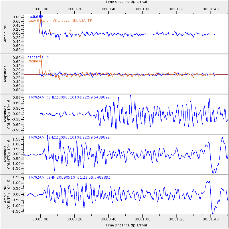
W24A Lazy 6 Ranch, Villanueva, NM, USA - Earthquake Result Viewer

| Earthquake location: |
Off Coast Of Ecuador |
| Earthquake latitude/longitude: |
1.4/-85.2 |
| Earthquake time(UTC): |
2009/05/10 (130) 01:16:06 GMT |
| Earthquake Depth: |
6.0 km |
| Earthquake Magnitude: |
5.5 MB, 5.7 MS, 6.1 MW, 6.1 MW |
| Earthquake Catalog/Contributor: |
WHDF/NEIC |
|
| Network: |
TA USArray Transportable Network (new EarthScope stations) |
| Station: |
W24A Lazy 6 Ranch, Villanueva, NM, USA |
| Lat/Lon: |
35.21 N/105.41 W |
| Elevation: |
1902 m |
|
| Distance: |
38.6 deg |
| Az: |
332.972 deg |
| Baz: |
146.304 deg |
| Ray Param: |
0.07550058 |
| Estimated Moho Depth: |
18.75 km |
| Estimated Crust Vp/Vs: |
1.98 |
| Assumed Crust Vp: |
6.419 km/s |
| Estimated Crust Vs: |
3.238 km/s |
| Estimated Crust Poisson's Ratio: |
0.33 |
|
| Radial Match: |
91.18123 % |
| Radial Bump: |
366 |
| Transverse Match: |
67.8994 % |
| Transverse Bump: |
400 |
| SOD ConfigId: |
2760 |
| Insert Time: |
2010-03-06 13:14:04.880 +0000 |
| GWidth: |
2.5 |
| Max Bumps: |
400 |
| Tol: |
0.001 |
|
Signal To Noise
| Channel | StoN | STA | LTA |
| TA:W24A: :BHZ:20090510T01:22:59.548989Z | 10.060279 | 6.506219E-7 | 6.4672356E-8 |
| TA:W24A: :BHN:20090510T01:22:59.548989Z | 3.0212798 | 2.969224E-7 | 9.827703E-8 |
| TA:W24A: :BHE:20090510T01:22:59.548989Z | 3.4865386 | 1.9444698E-7 | 5.577078E-8 |
| Arrivals |
| Ps | 3.1 SECOND |
| PpPs | 8.2 SECOND |
| PsPs/PpSs | 11 SECOND |


