You are here: Home > Network List > TA - USArray Transportable Network (new EarthScope stations) Stations List
> Station W24A Lazy 6 Ranch, Villanueva, NM, USA > Earthquake Result Viewer
W24A Lazy 6 Ranch, Villanueva, NM, USA - Earthquake Result Viewer
| Earthquake location: |
Iceland |
| Earthquake latitude/longitude: |
64.0/-21.0 |
| Earthquake time(UTC): |
2008/05/29 (150) 15:46:00 GMT |
| Earthquake Depth: |
10 km |
| Earthquake Magnitude: |
6.0 MB, 6.2 MS, 6.3 MW, 6.2 MW |
| Earthquake Catalog/Contributor: |
WHDF/NEIC |
|
| Network: |
TA USArray Transportable Network (new EarthScope stations) |
| Station: |
W24A Lazy 6 Ranch, Villanueva, NM, USA |
| Lat/Lon: |
35.21 N/105.41 W |
| Elevation: |
1902 m |
|
| Distance: |
56.6 deg |
| Az: |
282.534 deg |
| Baz: |
31.692 deg |
| Ray Param: |
0.06403702 |
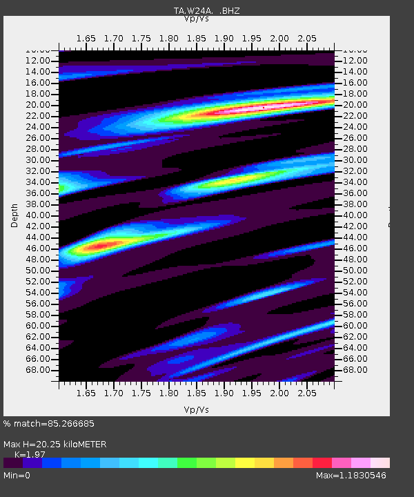
| Estimated Moho Depth: |
20.25 km |
| Estimated Crust Vp/Vs: |
1.97 |
| Assumed Crust Vp: |
6.419 km/s |
| Estimated Crust Vs: |
3.258 km/s |
| Estimated Crust Poisson's Ratio: |
0.33 |
|
| Radial Match: |
85.266685 % |
| Radial Bump: |
304 |
| Transverse Match: |
66.27462 % |
| Transverse Bump: |
400 |
| SOD ConfigId: |
2504 |
| Insert Time: |
2010-03-06 13:14:15.691 +0000 |
| GWidth: |
2.5 |
| Max Bumps: |
400 |
| Tol: |
0.001 |
|

Signal To Noise
| Channel | StoN | STA | LTA |
| TA:W24A: :BHZ:20080529T15:55:12.300017Z | 3.708755 | 3.542512E-7 | 9.551755E-8 |
| TA:W24A: :BHN:20080529T15:55:12.300017Z | 1.4333526 | 1.4787105E-7 | 1.0316447E-7 |
| TA:W24A: :BHE:20080529T15:55:12.300017Z | 1.120883 | 1.481669E-7 | 1.3218767E-7 |
| Arrivals |
| Ps | 3.2 SECOND |
| PpPs | 9.0 SECOND |
| PsPs/PpSs | 12 SECOND |


