You are here: Home > Network List > TA - USArray Transportable Network (new EarthScope stations) Stations List
> Station F21K Alatna River, AK, USA > Earthquake Result Viewer
F21K Alatna River, AK, USA - Earthquake Result Viewer
| Earthquake location: |
Sumbawa Region, Indonesia |
| Earthquake latitude/longitude: |
-8.3/116.5 |
| Earthquake time(UTC): |
2018/07/28 (209) 22:47:37 GMT |
| Earthquake Depth: |
6.4 km |
| Earthquake Magnitude: |
6.4 Mww |
| Earthquake Catalog/Contributor: |
NEIC PDE/us |
|
| Network: |
TA USArray Transportable Network (new EarthScope stations) |
| Station: |
F21K Alatna River, AK, USA |
| Lat/Lon: |
67.22 N/153.48 W |
| Elevation: |
597 m |
|
| Distance: |
97.6 deg |
| Az: |
23.129 deg |
| Baz: |
266.805 deg |
| Ray Param: |
0.04017487 |
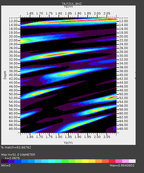
| Estimated Moho Depth: |
51.0 km |
| Estimated Crust Vp/Vs: |
2.10 |
| Assumed Crust Vp: |
6.455 km/s |
| Estimated Crust Vs: |
3.078 km/s |
| Estimated Crust Poisson's Ratio: |
0.35 |
|
| Radial Match: |
83.66762 % |
| Radial Bump: |
400 |
| Transverse Match: |
82.41105 % |
| Transverse Bump: |
400 |
| SOD ConfigId: |
13570011 |
| Insert Time: |
2019-04-30 16:37:51.626 +0000 |
| GWidth: |
2.5 |
| Max Bumps: |
400 |
| Tol: |
0.001 |
|

Signal To Noise
| Channel | StoN | STA | LTA |
| TA:F21K: :BHZ:20180728T23:00:40.500022Z | 7.309365 | 3.254992E-7 | 4.4531806E-8 |
| TA:F21K: :BHN:20180728T23:00:40.500022Z | 0.6975877 | 3.083632E-8 | 4.4204214E-8 |
| TA:F21K: :BHE:20180728T23:00:40.500022Z | 2.5375423 | 9.776024E-8 | 3.8525563E-8 |
| Arrivals |
| Ps | 8.8 SECOND |
| PpPs | 24 SECOND |
| PsPs/PpSs | 33 SECOND |


