You are here: Home > Network List > TA - USArray Transportable Network (new EarthScope stations) Stations List
> Station G21K Allakaket, AK, USA > Earthquake Result Viewer
G21K Allakaket, AK, USA - Earthquake Result Viewer
| Earthquake location: |
Sumbawa Region, Indonesia |
| Earthquake latitude/longitude: |
-8.3/116.5 |
| Earthquake time(UTC): |
2018/07/28 (209) 22:47:37 GMT |
| Earthquake Depth: |
6.4 km |
| Earthquake Magnitude: |
6.4 Mww |
| Earthquake Catalog/Contributor: |
NEIC PDE/us |
|
| Network: |
TA USArray Transportable Network (new EarthScope stations) |
| Station: |
G21K Allakaket, AK, USA |
| Lat/Lon: |
66.52 N/153.51 W |
| Elevation: |
446 m |
|
| Distance: |
97.5 deg |
| Az: |
23.843 deg |
| Baz: |
266.69 deg |
| Ray Param: |
0.04018973 |
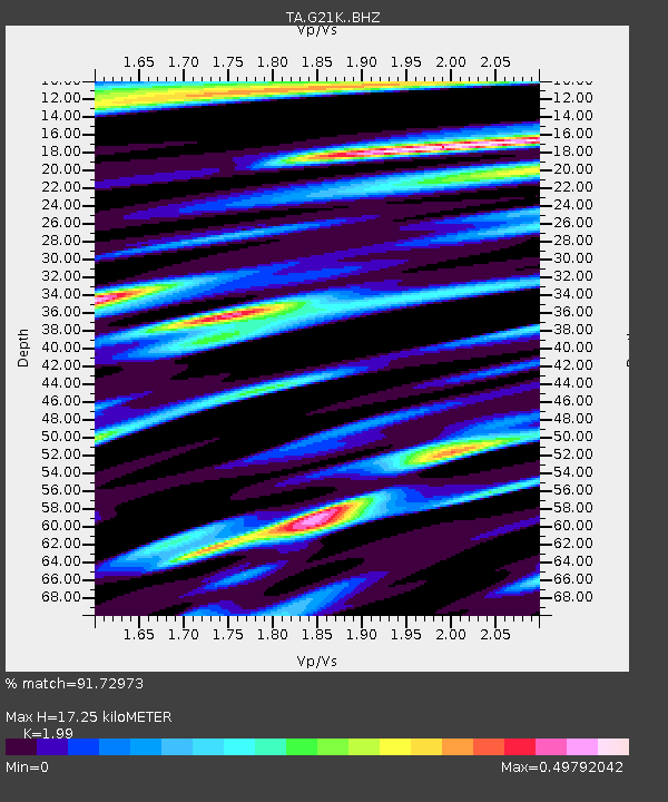
| Estimated Moho Depth: |
17.25 km |
| Estimated Crust Vp/Vs: |
1.99 |
| Assumed Crust Vp: |
6.455 km/s |
| Estimated Crust Vs: |
3.244 km/s |
| Estimated Crust Poisson's Ratio: |
0.33 |
|
| Radial Match: |
91.72973 % |
| Radial Bump: |
400 |
| Transverse Match: |
83.836945 % |
| Transverse Bump: |
400 |
| SOD ConfigId: |
13570011 |
| Insert Time: |
2019-04-30 16:37:57.339 +0000 |
| GWidth: |
2.5 |
| Max Bumps: |
400 |
| Tol: |
0.001 |
|
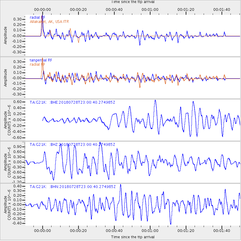
Signal To Noise
| Channel | StoN | STA | LTA |
| TA:G21K: :BHZ:20180728T23:00:40.274985Z | 5.470542 | 3.770008E-7 | 6.89147E-8 |
| TA:G21K: :BHN:20180728T23:00:40.274985Z | 1.9900807 | 7.752757E-8 | 3.8956994E-8 |
| TA:G21K: :BHE:20180728T23:00:40.274985Z | 1.7735261 | 8.200173E-8 | 4.6236554E-8 |
| Arrivals |
| Ps | 2.7 SECOND |
| PpPs | 7.9 SECOND |
| PsPs/PpSs | 11 SECOND |


