You are here: Home > Network List > TA - USArray Transportable Network (new EarthScope stations) Stations List
> Station K13K Kusilvak Mountain, AK, USA > Earthquake Result Viewer
K13K Kusilvak Mountain, AK, USA - Earthquake Result Viewer
| Earthquake location: |
Sumbawa Region, Indonesia |
| Earthquake latitude/longitude: |
-8.3/116.5 |
| Earthquake time(UTC): |
2018/07/28 (209) 22:47:37 GMT |
| Earthquake Depth: |
6.4 km |
| Earthquake Magnitude: |
6.4 Mww |
| Earthquake Catalog/Contributor: |
NEIC PDE/us |
|
| Network: |
TA USArray Transportable Network (new EarthScope stations) |
| Station: |
K13K Kusilvak Mountain, AK, USA |
| Lat/Lon: |
61.93 N/164.66 W |
| Elevation: |
204 m |
|
| Distance: |
92.0 deg |
| Az: |
27.667 deg |
| Baz: |
256.329 deg |
| Ray Param: |
0.041520912 |
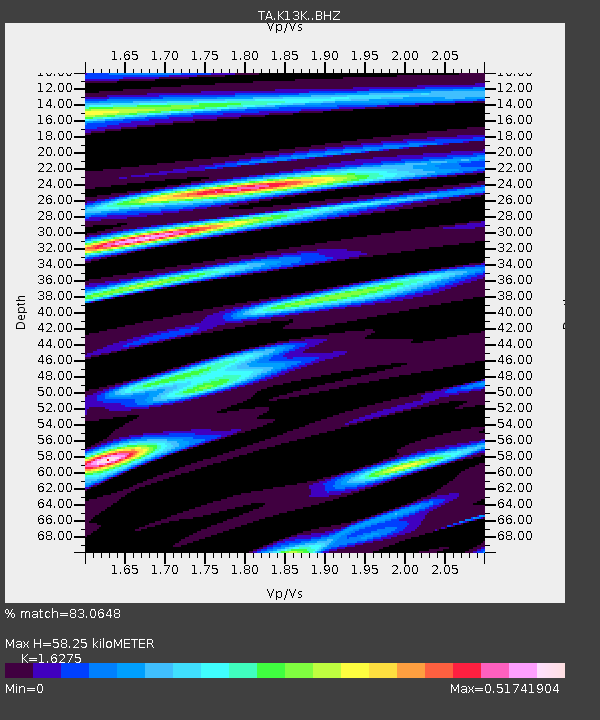
| Estimated Moho Depth: |
58.25 km |
| Estimated Crust Vp/Vs: |
1.63 |
| Assumed Crust Vp: |
6.1 km/s |
| Estimated Crust Vs: |
3.748 km/s |
| Estimated Crust Poisson's Ratio: |
0.20 |
|
| Radial Match: |
83.0648 % |
| Radial Bump: |
400 |
| Transverse Match: |
56.92257 % |
| Transverse Bump: |
400 |
| SOD ConfigId: |
13570011 |
| Insert Time: |
2019-04-30 16:38:11.530 +0000 |
| GWidth: |
2.5 |
| Max Bumps: |
400 |
| Tol: |
0.001 |
|

Signal To Noise
| Channel | StoN | STA | LTA |
| TA:K13K: :BHZ:20180728T23:00:15.324973Z | 4.980613 | 6.19131E-7 | 1.2430819E-7 |
| TA:K13K: :BHN:20180728T23:00:15.324973Z | 0.88597494 | 1.2662188E-7 | 1.4291813E-7 |
| TA:K13K: :BHE:20180728T23:00:15.324973Z | 2.0546284 | 1.8599745E-7 | 9.052607E-8 |
| Arrivals |
| Ps | 6.1 SECOND |
| PpPs | 25 SECOND |
| PsPs/PpSs | 31 SECOND |


