You are here: Home > Network List > CI - Caltech Regional Seismic Network Stations List
> Station PHL Parkhill, California, USA > Earthquake Result Viewer
PHL Parkhill, California, USA - Earthquake Result Viewer
| Earthquake location: |
Southeast Of Honshu, Japan |
| Earthquake latitude/longitude: |
34.0/139.3 |
| Earthquake time(UTC): |
2000/07/30 (212) 12:48:55 GMT |
| Earthquake Depth: |
10 km |
| Earthquake Magnitude: |
5.5 MB |
| Earthquake Catalog/Contributor: |
WHDF/NEIC |
|
| Network: |
CI Caltech Regional Seismic Network |
| Station: |
PHL Parkhill, California, USA |
| Lat/Lon: |
35.41 N/120.55 W |
| Elevation: |
351 m |
|
| Distance: |
78.4 deg |
| Az: |
55.154 deg |
| Baz: |
303.374 deg |
| Ray Param: |
0.049649023 |
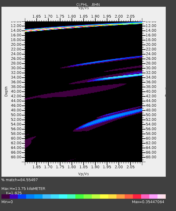
| Estimated Moho Depth: |
13.75 km |
| Estimated Crust Vp/Vs: |
1.62 |
| Assumed Crust Vp: |
6.183 km/s |
| Estimated Crust Vs: |
3.805 km/s |
| Estimated Crust Poisson's Ratio: |
0.20 |
|
| Radial Match: |
84.55497 % |
| Radial Bump: |
400 |
| Transverse Match: |
75.6523 % |
| Transverse Bump: |
400 |
| SOD ConfigId: |
3753 |
| Insert Time: |
2010-02-26 02:06:54.235 +0000 |
| GWidth: |
2.5 |
| Max Bumps: |
400 |
| Tol: |
0.001 |
|

Signal To Noise
| Channel | StoN | STA | LTA |
| CI:PHL: :BHN:20000730T13:00:24.922017Z | 1.4946109 | 1.4797465E-6 | 9.900547E-7 |
| CI:PHL: :BHE:20000730T13:00:24.922017Z | 3.402017 | 2.817965E-6 | 8.2832184E-7 |
| CI:PHL: :BHZ:20000730T13:00:24.922017Z | 3.0517783 | 1.5148847E-6 | 4.963941E-7 |
| Arrivals |
| Ps | 1.4 SECOND |
| PpPs | 5.7 SECOND |
| PsPs/PpSs | 7.1 SECOND |


