You are here: Home > Network List > CI - Caltech Regional Seismic Network Stations List
> Station PHL Parkhill, California, USA > Earthquake Result Viewer
PHL Parkhill, California, USA - Earthquake Result Viewer
| Earthquake location: |
New Britain Region, P.N.G. |
| Earthquake latitude/longitude: |
-5.2/151.8 |
| Earthquake time(UTC): |
2000/11/18 (323) 06:54:58 GMT |
| Earthquake Depth: |
33 km |
| Earthquake Magnitude: |
6.2 MB, 6.6 MS, 6.8 MW, 6.8 MW |
| Earthquake Catalog/Contributor: |
WHDF/NEIC |
|
| Network: |
CI Caltech Regional Seismic Network |
| Station: |
PHL Parkhill, California, USA |
| Lat/Lon: |
35.41 N/120.55 W |
| Elevation: |
351 m |
|
| Distance: |
91.1 deg |
| Az: |
54.722 deg |
| Baz: |
264.423 deg |
| Ray Param: |
0.04162166 |
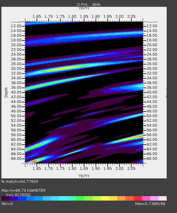
| Estimated Moho Depth: |
69.75 km |
| Estimated Crust Vp/Vs: |
1.61 |
| Assumed Crust Vp: |
6.183 km/s |
| Estimated Crust Vs: |
3.834 km/s |
| Estimated Crust Poisson's Ratio: |
0.19 |
|
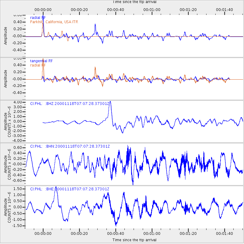
| Radial Match: |
84.77804 % |
| Radial Bump: |
314 |
| Transverse Match: |
51.534798 % |
| Transverse Bump: |
400 |
| SOD ConfigId: |
3744 |
| Insert Time: |
2010-02-26 02:06:55.135 +0000 |
| GWidth: |
2.5 |
| Max Bumps: |
400 |
| Tol: |
0.001 |
|
Signal To Noise
| Channel | StoN | STA | LTA |
| CI:PHL: :BHN:20001118T07:07:28.37301Z | 0.60948104 | 1.4088107E-7 | 2.3114924E-7 |
| CI:PHL: :BHE:20001118T07:07:28.37301Z | 0.9460924 | 2.484772E-7 | 2.626352E-7 |
| CI:PHL: :BHZ:20001118T07:07:28.37301Z | 1.8910353 | 3.979778E-7 | 2.1045497E-7 |
| Arrivals |
| Ps | 7.1 SECOND |
| PpPs | 29 SECOND |
| PsPs/PpSs | 36 SECOND |


