You are here: Home > Network List > CI - Caltech Regional Seismic Network Stations List
> Station PHL Parkhill, California, USA > Earthquake Result Viewer
PHL Parkhill, California, USA - Earthquake Result Viewer
| Earthquake location: |
New Ireland Region, P.N.G. |
| Earthquake latitude/longitude: |
-4.0/152.2 |
| Earthquake time(UTC): |
2000/11/16 (321) 04:54:56 GMT |
| Earthquake Depth: |
33 km |
| Earthquake Magnitude: |
6.0 MB, 8.2 MS, 8.0 MW, 8.0 ME |
| Earthquake Catalog/Contributor: |
WHDF/NEIC |
|
| Network: |
CI Caltech Regional Seismic Network |
| Station: |
PHL Parkhill, California, USA |
| Lat/Lon: |
35.41 N/120.55 W |
| Elevation: |
351 m |
|
| Distance: |
90.1 deg |
| Az: |
54.682 deg |
| Baz: |
265.206 deg |
| Ray Param: |
0.04169584 |
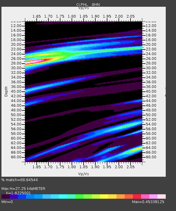
| Estimated Moho Depth: |
27.25 km |
| Estimated Crust Vp/Vs: |
1.62 |
| Assumed Crust Vp: |
6.183 km/s |
| Estimated Crust Vs: |
3.811 km/s |
| Estimated Crust Poisson's Ratio: |
0.19 |
|
| Radial Match: |
88.64544 % |
| Radial Bump: |
305 |
| Transverse Match: |
73.35879 % |
| Transverse Bump: |
400 |
| SOD ConfigId: |
3744 |
| Insert Time: |
2010-02-26 02:06:56.104 +0000 |
| GWidth: |
2.5 |
| Max Bumps: |
400 |
| Tol: |
0.001 |
|

Signal To Noise
| Channel | StoN | STA | LTA |
| CI:PHL: :BHN:20001116T05:07:21.922007Z | 0.45904613 | 1.726866E-7 | 3.7618574E-7 |
| CI:PHL: :BHE:20001116T05:07:21.922007Z | 0.3957535 | 5.1878584E-7 | 1.3108813E-6 |
| CI:PHL: :BHZ:20001116T05:07:21.922007Z | 0.68817556 | 3.0282848E-7 | 4.400454E-7 |
| Arrivals |
| Ps | 2.8 SECOND |
| PpPs | 11 SECOND |
| PsPs/PpSs | 14 SECOND |


