You are here: Home > Network List > CI - Caltech Regional Seismic Network Stations List
> Station PHL Parkhill, California, USA > Earthquake Result Viewer
PHL Parkhill, California, USA - Earthquake Result Viewer

| Earthquake location: |
Volcano Islands, Japan Region |
| Earthquake latitude/longitude: |
22.3/143.7 |
| Earthquake time(UTC): |
2000/03/28 (088) 11:00:22 GMT |
| Earthquake Depth: |
126 km |
| Earthquake Magnitude: |
6.8 MB, 7.6 MS, 7.6 MW, 7.6 MW |
| Earthquake Catalog/Contributor: |
WHDF/NEIC |
|
| Network: |
CI Caltech Regional Seismic Network |
| Station: |
PHL Parkhill, California, USA |
| Lat/Lon: |
35.41 N/120.55 W |
| Elevation: |
351 m |
|
| Distance: |
81.8 deg |
| Az: |
55.204 deg |
| Baz: |
291.45 deg |
| Ray Param: |
0.04703782 |
| Estimated Moho Depth: |
21.75 km |
| Estimated Crust Vp/Vs: |
1.92 |
| Assumed Crust Vp: |
6.183 km/s |
| Estimated Crust Vs: |
3.22 km/s |
| Estimated Crust Poisson's Ratio: |
0.31 |
|
| Radial Match: |
96.12519 % |
| Radial Bump: |
400 |
| Transverse Match: |
92.530876 % |
| Transverse Bump: |
400 |
| SOD ConfigId: |
3744 |
| Insert Time: |
2010-02-26 02:06:58.389 +0000 |
| GWidth: |
2.5 |
| Max Bumps: |
400 |
| Tol: |
0.001 |
|
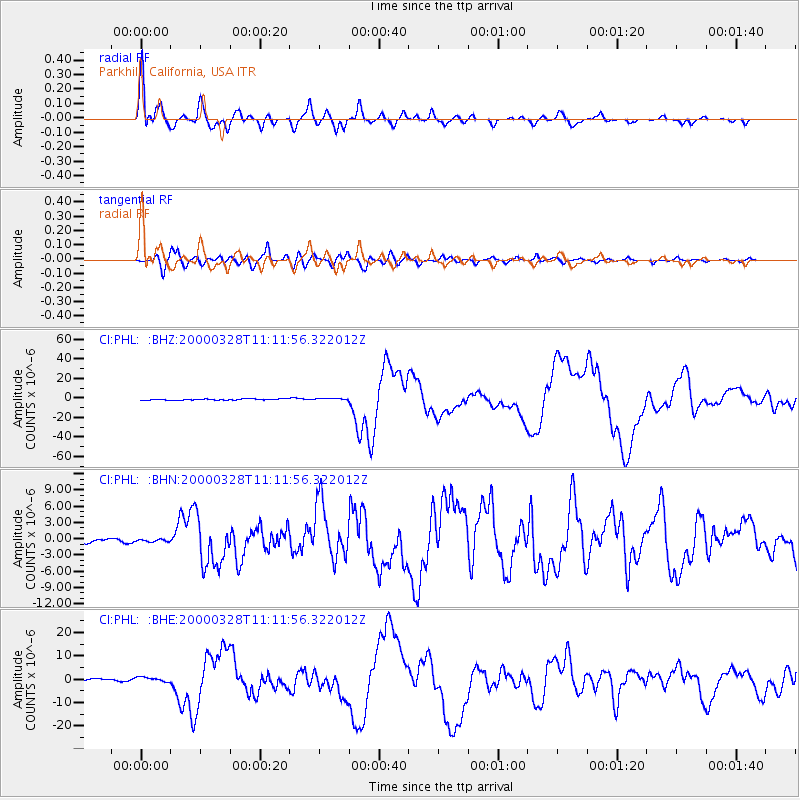
Signal To Noise
| Channel | StoN | STA | LTA |
| CI:PHL: :BHN:20000328T11:11:56.322012Z | 0.72085863 | 2.2029405E-7 | 3.055995E-7 |
| CI:PHL: :BHE:20000328T11:11:56.322012Z | 2.3879697 | 1.0654378E-6 | 4.4616888E-7 |
| CI:PHL: :BHZ:20000328T11:11:56.322012Z | 1.7282517 | 1.0756225E-6 | 6.223761E-7 |
| Arrivals |
| Ps | 3.3 SECOND |
| PpPs | 10 SECOND |
| PsPs/PpSs | 13 SECOND |


