You are here: Home > Network List > TA - USArray Transportable Network (new EarthScope stations) Stations List
> Station E18A Harlowton, MT, USA > Earthquake Result Viewer
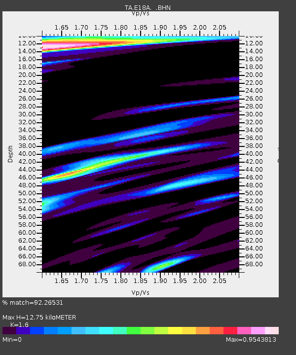
E18A Harlowton, MT, USA - Earthquake Result Viewer
| Earthquake location: |
Volcano Islands, Japan Region |
| Earthquake latitude/longitude: |
22.0/142.7 |
| Earthquake time(UTC): |
2007/09/28 (271) 13:38:59 GMT |
| Earthquake Depth: |
276 km |
| Earthquake Magnitude: |
6.7 MB, 7.4 MW, 7.4 MW |
| Earthquake Catalog/Contributor: |
WHDF/NEIC |
|
| Network: |
TA USArray Transportable Network (new EarthScope stations) |
| Station: |
E18A Harlowton, MT, USA |
| Lat/Lon: |
46.57 N/109.91 W |
| Elevation: |
1459 m |
|
| Distance: |
85.5 deg |
| Az: |
41.319 deg |
| Baz: |
297.367 deg |
| Ray Param: |
0.044016432 |
| Estimated Moho Depth: |
12.75 km |
| Estimated Crust Vp/Vs: |
1.60 |
| Assumed Crust Vp: |
6.518 km/s |
| Estimated Crust Vs: |
4.074 km/s |
| Estimated Crust Poisson's Ratio: |
0.18 |
|
| Radial Match: |
92.26531 % |
| Radial Bump: |
400 |
| Transverse Match: |
85.21191 % |
| Transverse Bump: |
400 |
| SOD ConfigId: |
2564 |
| Insert Time: |
2010-03-06 13:18:58.281 +0000 |
| GWidth: |
2.5 |
| Max Bumps: |
400 |
| Tol: |
0.001 |
|

Signal To Noise
| Channel | StoN | STA | LTA |
| TA:E18A: :BHN:20070928T13:50:35.450024Z | 19.067787 | 2.8779068E-6 | 1.509303E-7 |
| TA:E18A: :BHE:20070928T13:50:35.450024Z | 18.906952 | 4.5527713E-6 | 2.407988E-7 |
| TA:E18A: :BHZ:20070928T13:50:35.450024Z | 105.63844 | 1.4109089E-5 | 1.3356016E-7 |
| Arrivals |
| Ps | 1.2 SECOND |
| PpPs | 5.0 SECOND |
| PsPs/PpSs | 6.2 SECOND |


