You are here: Home > Network List > TA - USArray Transportable Network (new EarthScope stations) Stations List
> Station B18K Kokolik River, AK, USA > Earthquake Result Viewer
B18K Kokolik River, AK, USA - Earthquake Result Viewer
| Earthquake location: |
Near East Coast Of Honshu, Japan |
| Earthquake latitude/longitude: |
37.2/141.2 |
| Earthquake time(UTC): |
2018/07/31 (212) 08:42:20 GMT |
| Earthquake Depth: |
10 km |
| Earthquake Magnitude: |
5.4 Mww |
| Earthquake Catalog/Contributor: |
NEIC PDE/us |
|
| Network: |
TA USArray Transportable Network (new EarthScope stations) |
| Station: |
B18K Kokolik River, AK, USA |
| Lat/Lon: |
69.36 N/161.80 W |
| Elevation: |
222 m |
|
| Distance: |
44.2 deg |
| Az: |
25.244 deg |
| Baz: |
253.925 deg |
| Ray Param: |
0.07205104 |
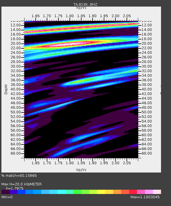
| Estimated Moho Depth: |
20.0 km |
| Estimated Crust Vp/Vs: |
1.80 |
| Assumed Crust Vp: |
5.906 km/s |
| Estimated Crust Vs: |
3.286 km/s |
| Estimated Crust Poisson's Ratio: |
0.28 |
|
| Radial Match: |
80.15965 % |
| Radial Bump: |
400 |
| Transverse Match: |
67.729385 % |
| Transverse Bump: |
400 |
| SOD ConfigId: |
13570011 |
| Insert Time: |
2019-04-30 16:58:33.738 +0000 |
| GWidth: |
2.5 |
| Max Bumps: |
400 |
| Tol: |
0.001 |
|

Signal To Noise
| Channel | StoN | STA | LTA |
| TA:B18K: :BHZ:20180731T08:49:58.899991Z | 4.5611534 | 8.798186E-7 | 1.9289389E-7 |
| TA:B18K: :BHN:20180731T08:49:58.899991Z | 1.7331239 | 1.8668509E-7 | 1.0771595E-7 |
| TA:B18K: :BHE:20180731T08:49:58.899991Z | 3.0132194 | 2.1425498E-7 | 7.1105006E-8 |
| Arrivals |
| Ps | 2.8 SECOND |
| PpPs | 9.0 SECOND |
| PsPs/PpSs | 12 SECOND |


