You are here: Home > Network List > CI - Caltech Regional Seismic Network Stations List
> Station PHL Parkhill, California, USA > Earthquake Result Viewer
PHL Parkhill, California, USA - Earthquake Result Viewer
| Earthquake location: |
Kermadec Islands, New Zealand |
| Earthquake latitude/longitude: |
-29.7/-178.6 |
| Earthquake time(UTC): |
2001/06/03 (154) 02:41:57 GMT |
| Earthquake Depth: |
178 km |
| Earthquake Magnitude: |
6.8 MB, 7.2 MW, 7.1 MW |
| Earthquake Catalog/Contributor: |
WHDF/NEIC |
|
| Network: |
CI Caltech Regional Seismic Network |
| Station: |
PHL Parkhill, California, USA |
| Lat/Lon: |
35.41 N/120.55 W |
| Elevation: |
351 m |
|
| Distance: |
84.7 deg |
| Az: |
44.135 deg |
| Baz: |
227.896 deg |
| Ray Param: |
0.04485036 |
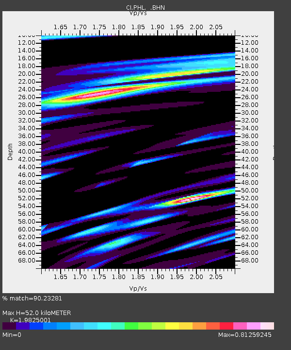
| Estimated Moho Depth: |
52.0 km |
| Estimated Crust Vp/Vs: |
1.98 |
| Assumed Crust Vp: |
6.183 km/s |
| Estimated Crust Vs: |
3.119 km/s |
| Estimated Crust Poisson's Ratio: |
0.33 |
|
| Radial Match: |
90.23281 % |
| Radial Bump: |
400 |
| Transverse Match: |
81.1653 % |
| Transverse Bump: |
400 |
| SOD ConfigId: |
3787 |
| Insert Time: |
2010-02-26 02:07:20.382 +0000 |
| GWidth: |
2.5 |
| Max Bumps: |
400 |
| Tol: |
0.001 |
|
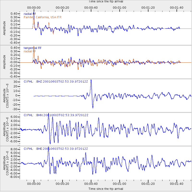
Signal To Noise
| Channel | StoN | STA | LTA |
| CI:PHL: :BHN:20010603T02:53:39.972012Z | 0.5769275 | 1.6228799E-7 | 2.8129705E-7 |
| CI:PHL: :BHE:20010603T02:53:39.972012Z | 0.8678315 | 2.558583E-7 | 2.9482484E-7 |
| CI:PHL: :BHZ:20010603T02:53:39.972012Z | 2.852099 | 6.677783E-7 | 2.3413573E-7 |
| Arrivals |
| Ps | 8.4 SECOND |
| PpPs | 25 SECOND |
| PsPs/PpSs | 33 SECOND |


