You are here: Home > Network List > TA - USArray Transportable Network (new EarthScope stations) Stations List
> Station I30M Mount Dempster, Yukon, CAN > Earthquake Result Viewer
I30M Mount Dempster, Yukon, CAN - Earthquake Result Viewer
| Earthquake location: |
Near East Coast Of Honshu, Japan |
| Earthquake latitude/longitude: |
37.2/141.2 |
| Earthquake time(UTC): |
2018/07/31 (212) 08:42:20 GMT |
| Earthquake Depth: |
10 km |
| Earthquake Magnitude: |
5.4 Mww |
| Earthquake Catalog/Contributor: |
NEIC PDE/us |
|
| Network: |
TA USArray Transportable Network (new EarthScope stations) |
| Station: |
I30M Mount Dempster, Yukon, CAN |
| Lat/Lon: |
65.22 N/136.38 W |
| Elevation: |
1399 m |
|
| Distance: |
53.9 deg |
| Az: |
31.154 deg |
| Baz: |
281.318 deg |
| Ray Param: |
0.06581949 |
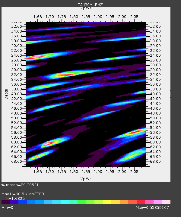
| Estimated Moho Depth: |
60.5 km |
| Estimated Crust Vp/Vs: |
1.68 |
| Assumed Crust Vp: |
6.566 km/s |
| Estimated Crust Vs: |
3.903 km/s |
| Estimated Crust Poisson's Ratio: |
0.23 |
|
| Radial Match: |
89.29521 % |
| Radial Bump: |
400 |
| Transverse Match: |
83.333405 % |
| Transverse Bump: |
400 |
| SOD ConfigId: |
13570011 |
| Insert Time: |
2019-04-30 16:59:38.196 +0000 |
| GWidth: |
2.5 |
| Max Bumps: |
400 |
| Tol: |
0.001 |
|
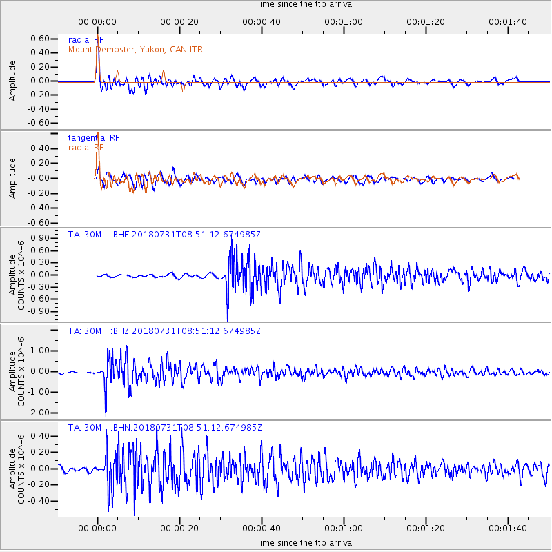
Signal To Noise
| Channel | StoN | STA | LTA |
| TA:I30M: :BHZ:20180731T08:51:12.674985Z | 15.043362 | 6.6028736E-7 | 4.3892275E-8 |
| TA:I30M: :BHN:20180731T08:51:12.674985Z | 4.730381 | 1.9473762E-7 | 4.116743E-8 |
| TA:I30M: :BHE:20180731T08:51:12.674985Z | 11.346499 | 3.992125E-7 | 3.5183756E-8 |
| Arrivals |
| Ps | 6.7 SECOND |
| PpPs | 23 SECOND |
| PsPs/PpSs | 30 SECOND |


